


Danube Cycle Path Stage 4 North Bank: Grein - Emmersdorf


- culturally interesting
- Multi-day tour
Interactive elevation profile
Create PDF
Tour-Details
Paths covering:
Attention: The Danube cycle path will be renovated until April 2021 in the area Marbach (Krummnußbaum/DuB) - Klein-Pöchlarn and largely diverted in Persenbeug on the south bank to Ybbs and from there to Pöchlarn. Cyclists directly approaching the construction site will be diverted to the B3 in Krummnußbaum/DuB and back to the Treppelweg in the area of Klein-Pöchlarn.
Technique: *
Quality of experience: ***
Recommended season:
- April
- May
- June
- July
- August
- September
- October
Properties:
- Multi-stage route
- Refreshment stops available
- Cultural/historical value
- Botanical highlights
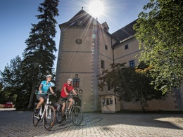
Before you set off you should take a stroll through – maybe even a guided tour of – charming Grein, walking across the picturesque old main square to the historic city theater, to the Upper Austrian Navigation Museum or to Greinburg Castle. A visit to the nearby “Stillensteinklamm”, a ravine with impressive rock formations, would be another option.
Soon you will pass the densely wooded slopes of the Strudengau, a section of the Danube Valley whose name comes from the swirls in the river (“Struden”), which used to pose a problem for mariners.
Near St. Nikola the Werfenstein ruins rise over the Danube. Chains were thrown from here to Wörth Island to stop ships from going through in the past. Following romantic Donauleiten and after passing Sarmingstein and Hirschenau, you reach Persenbeug, home to what is probably one of the most famous Austrian Danube power stations. It is open for guided tours (advance reservations required).
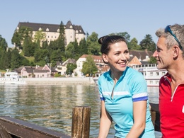
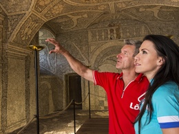
Two more side trips will lure you away from the Danube. Near Marbach you can, if your bike and you are ready for some uphill riding, visit the pilgrimage church Maria Taferl. At this beautiful Baroque basilica you can enjoy the breathtaking view of the Danube Valley. Near Klein-Pöchlarn you can take a trip to nearby Artstetten. In the castle you can see a documentation of Archduke Franz Ferdinand’s life. The successor to the throne, who was killed in 1914 in Sarajevo, and his wife are buried in the crypt that is also located there. At the final destination of this stage, Emmersdorf, the Danube bridge allows a visit to the sights in Melk on the other side of the river.
We recommend: In Grein you take the ferry (or shortly before Grein the bridge) to the south bank and continue there on the Danube cycle path. At the Danube power plant Ybbs-Persenbeug you will be able to reach the northern shore again. The Danube-shore trail takes you from Grein to Sarmingstein.
Directions:
Grein - St. Nikola - Weins - Persenbeug-Gottsdorf - Marbach - Klein-Pöchlarn - Emmersdorf
Route description
You start your tour in Grein and follow the B3, which runs along the Danube. The thickly wooded slopes to the left and right of the river are a remarkable sight. Even from a distance you can see Werfenstein Castle in St. Nikola, whose history dates back to the 12th c. After Sarmingstein (landing stage) and Hirschenau you reach the border between the two Austrian provinces Upper and Lower Austria. After Kalkgrub and Weins, you pass the impressive Danube power plant Ybbs-Persenbeug. This is the transition point between two stretches of the Danube: the Strudengau and the Nibelungengau.
Throughout the course of your following route, you have a beautiful view of the pilgrimage church Maria Taferl. In Persenbeug Gottsdorf you leave the B3 and follow the course of the Danube only to reach the main road again, which you take to Emmersdorf. You pass through small towns like Marbach an der Donau and Klein-Pöchlarn, which are inviting places to stop for a small snack. Artstetten Castle above Klein-Pöchlarn is worth a visit. From Emmersdorf, you make a side trip to Melk on the other side of the river. There you can visit the splendid 18th c Benedictine abbey, which you've already seen from the bike path. The monastery is open to visitors year-round.
We recommend: In Grein you take the ferry (or shortly before Grein the bridge) to the south bank and continue there on the Danube cycle path. At the Danube power plant Ybbs-Persenbeug you will be able to reach the northern shore again. The Danube-shore trail takes you from Grein to Sarmingstein.
further information:
- Multi-day tour
- Board possible
")
")
")
")
")
")
")
")

")
")
")

")
")
")

")
 (© Verein Grein Tourismus)")
")
")

")
")
")

Getting there
Follow the B3 (Donaustrasse) to Grein
Public Transit
Bus station at the Grein boat station
Parking
Parking lot at the campgrounds in Grein
- Spring
- Summer
- Autumn
Please get in touch for more information.
Lindengasse 9
4040 Linz
Phone +43 732 7277 - 800
Fax machine +43 732 7277 - 804
E-Mail info@donauregion.at
Web www.donauregion.at
Interactive elevation profile
Create PDF
Tour-Details
Paths covering:
Suggest changes
Please let us know how we can improve the quality of this object or if there is any incorrect information on this page (eg. opening hours, contact, etc.).
Please fill in all fields marked *.