
Grein: Grein Donaublick Loop


4360 Grein

Kalvarienberg - Mayerhofer Chapel - Donaublick Rest Area - Moserjäger Chapel - Lehen - Mühlberg - Blue Cross - Donaublick - Grein
Recommended season:
- April
- May
- June
- July
- August
- September
- October
- Loop
- Scenic
- Cultural/historical value
POINTS OF INTEREST ALONG THE WAY:
Greinburg Castle
Historic City Theater Grein & City Museum, Gallery in Granite
Historic Town Square and City Fountain, Parish Church
SPIRITUAL HIKING ON THE DONAUSTEIG:
St. Anthony Monastery
The St. Anthony House is a former Franciscan monastery. It is located in the center of Grein near the Danube. The small residential community tries to walk an inner “pilgrimage to the sources of faith” following the example of St. Anthony and to discover the springs of life together with the guests: in the hour prayer, in the celebration of the liturgy, in silence, in conversation...
For closed groups, reflection days or similar events are gladly organized. But above all, the St. Anthony House invites individuals all year round to days of silence, reflection, and a monastery vacation.
Please register in advance:
Tel.: +43 (7268) 7861
Tel.: +43 (7268) 7851
E-mail: haus.antonius@aon.at
- On the “Grein Donaublick Loop” I reflect on how I look, my size, my appearance, my face when I am happy, sad... my “demeanor”, my expression, my impact.
- I look at the Danube's shore and try to catch my face/reflection – due to the movement of the current, this is not easy.
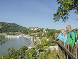
The circular route starts at the hiking info point at the Danube bank. We follow the Donausteig to the rest area at Kalvarienberg and the Gallery in Granite. After this detour with a magnificent view of the Danube and the town of Grein, we continue into Jubiläumstraße (left; the Donausteig continues right into Wienerweg). After 300 m we turn left (Mayrhoferweg). After another left curve, it goes down again towards the center. The street ends in Friedhofstraße, where we turn right and go under the railway. At the end of the street, we turn left (Grillparzerstraße) and after about 200 m turn right again (Stifterstraße). We now follow this street until we meet the Donausteig again. We follow it over the Mühlberg (rest area) to Grein, through Kreuznerstraße and via the castle park into the center. Over the town square and Donaugasse, we reach our starting point.Tip:
This route is presented to you by the Danube Upper Austria tourism regionEquipment:
Hiking backpack (incl. rain cover), sturdy footwearAdditional information:
Grein Tourism Association
Stadtplatz 7
4360 Grein
Tel./Fax: 0043(0)7268/7055
info.grein@oberoesterreich.at
www.oberoesterreich.at/grein
Paths covering:
further information:
- Flatly
")


")
")
 (© Verein Grein Tourismus)")
")
")

Getting there
Car:
from Vienna: Autobahn A1 - Exit Ybbs - B3
from Linz: Autobahn A1 - Exit Enns - B3
or Exit Amstetten - State Road 119
Train: Donauuferbahn - Grein station
Westbahn - Amstetten station and by bus to Grein
Airplane: Blue Danube Airport Linz/Hörsching
Vienna/Schwechat Airport
Ship:
Danube shipping Wurm+Köck
Linz-Grein-Wachau-Vienna
every Saturday arrival Grein 12 o’clock
Excursion ship MS Kaiserin Elisabeth
Linz-Grein-Wachau-Vienna
every Friday arrival Grein 11:30 a.m.
Public Transit
Rail connection: Donauuferbahn Grein/Stadt and Grein/Bad Kreuzen
Parking
Esperanto parking lot (P4), Nekarsteinach parking lot (P3)
- Spring
- Summer
- Autumn
Please get in touch for more information.
Stadtplatz 7
4360 Grein
Phone +43 7268 7055
E-Mail info.grein@oberoesterreich.at
Web www.donauregion.at/grein
Web www.donauregion.at
https://www.donauregion.at
Altitude profile - Grein: Grein Donaublick Loop
Suggest changes
Please let us know how we can improve the quality of this object or if there is any incorrect information on this page (eg. opening hours, contact, etc.).
Please fill in all fields marked *.