Jochenstein-Wanderung (8)
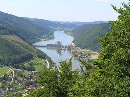
From Engelhartszell town hall, the route leads through Marktstraße and Siedlungsstraße to the outdoor pool and on to the Jochenstein power station, which owes its name to the granite block in the Danube.
It is said that the devil wanted to drown all the believers in Passau. He worked all night, but as he was about to place the last rock on the wall, the bell of Engelszell Abbey rang out and the wall shattered. Enraged, the devil hurled the last rock into the river bed - the "Jochenstein".
The Jochenstein power station was built between 1952 and 1956 as the largest river power station in Central Europe. Tel. +43(0)7717/8032
The way back leads past the "Bernhard" snack station uphill into the forest until you reach "Karlhütt" and then "Ziehobl" after approx. 30 minutes. The route then continues for approx. 1.5 km on a goods road past the village of Raad. Turn left and walk downhill back to Engelhartszell.
- Spring
- Summer
- Autumn
Please get in touch for more information.
St. Aegidi 10
4725 St. Aegidi
Phone +43 7717 7355 - 0
Fax machine +43 7717 7355 - 4
E-Mail gemeinde@st-aegidi.ooe.gv.at
Web www.st-aegidi.at
Suggest changes
Please let us know how we can improve the quality of this object or if there is any incorrect information on this page (eg. opening hours, contact, etc.).
Fields marked with an asterisk (*) are obligatory


