


Stillensteinklamm Gorge and high route (9+7)


- Suitable for families
- Flatly
Interactive elevation profile
Create PDF
Tour-Details
Starting place: 4360 Grein
Destination: 4360 Grein
duration: 4h 34m
length: 15,3 km
Altitude difference (uphill): 458m
Altitude difference (downhill): 465m
Lowest point: 228m
Highest point: 520m
difficulty: medium
condition: medium
panoramic view: Dreamtour
Paths covering:
Asphalt, Other
powered by TOURDATA | Suggest a change
Short description:
Stillensteinklamm Gorge is among the most scenic hiking trails in the lower Mühlviertel and has been awarded the OÖ Hiking Seal of Quality
Stillensteinklamm Gorge is among the most scenic hiking trails in the lower Mühlviertel and has been awarded the OÖ Hiking Seal of Quality
Technique: ***
Quality of experience: ******
Recommended season:
- January
- February
- March
- April
- May
- June
- July
- August
- September
- October
- November
- December
Properties:
- Loop
- Refreshment stops available
- Family friendly
- Geological highlights
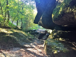
Starting point for the hike is at the hiking info-point at the Donaulände. The well signpostet family hiking trail No. 9 initially leads through the little Danube town of Grein, past the gallery in granite, across Kreuzleiten hill to Werfensteinblick viewpoint. Continue to the gorge entrance at Gießenbachmühle. Now walk uphill through the gorge, past the spectacular granite formations to the highlight of the hike, the "Quiet rock". Here the stream flows underground for a bit. Then the trail continues, first through the forest, then across meadows to Aumühle Inn. High route No. 7 leads through the gentle Mühlviertel hillscape, first along a forest trail, later on agricultural roads back to the little Danube town of Grein.
Tip:
On the way back, a detour from hiking trail No. 7 to Marienstein, a rock formation of granite with a statue of the Virgin Mary - wonderful views of Grein and the Danube Valley all the way to the Alps! To stop off for lunch, we recommend Aumühle country inn for a short break and to recharge your batteries, before climbing up through the gorge to Gießenbachmühle snack-bar.
Safety guidelines:
Accessible all year round at your own risk. Not recommended in wet and snowy conditions, be careful!
Equipment:
good footwear is essential
Additional information:
Starting point: Hiking info point on the Donaulände
Destination: Hiking info point on the Donaulände
further information:
- Flatly
- Board possible
Accessibility / arrival
Parking
Parking in Grein
Public Transit
Location and getting there
How to arrive in the Danube Upper Austrian region?
The fast way to your destination – by train, bus, car, boat or plane.
Parking
Parking in Grein
Most economical season
- Spring
- Summer
- Autumn
- Early winter
- Deep winter
Please get in touch for more information.
Stadtplatz 7
4360 Grein
Phone +43 7268 7055
E-Mail info.grein@oberoesterreich.at
Web www.donauregion.at/grein
https://www.donauregion.at/grein
Interactive elevation profile
Create PDF
Tour-Details
Starting place: 4360 Grein
Destination: 4360 Grein
duration: 4h 34m
length: 15,3 km
Altitude difference (uphill): 458m
Altitude difference (downhill): 465m
Lowest point: 228m
Highest point: 520m
difficulty: medium
condition: medium
panoramic view: Dreamtour
Paths covering:
Asphalt, Other
powered by TOURDATA | Suggest a change
Suggest changes
Please let us know how we can improve the quality of this object or if there is any incorrect information on this page (eg. opening hours, contact, etc.).
Please fill in all fields marked *.