


Gobelwarte-circular path (1-2)


- Suitable for families
- Flatly
Interactive elevation profile
Create PDF
Tour-Details
Path number: 1+2
Starting place: 4360 Grein
Destination: 4360 Grein
duration: 1h 39m
length: 5,2 km
Altitude difference (uphill): 249m
Altitude difference (downhill): 249m
Lowest point: 234m
Highest point: 483m
difficulty: easy
condition: easy
panoramic view: Dreamtour
Paths covering:
Other
powered by TOURDATA | Suggest a change
Short description:
Easy, varied circuit hike with spectacular lookout, offering a fabulous 360°-panorama.
Easy, varied circuit hike with spectacular lookout, offering a fabulous 360°-panorama.
Technique: **
Quality of experience: ******
Recommended season:
- January
- February
- March
- April
- May
- June
- July
- August
- September
- October
- November
- December
Properties:
- Loop
- Scenic
- Refreshment stops available
- Family friendly
- Summit route
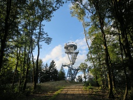
This hike up to Gobelwarte observation deck starts at the Red Cross by Donaubundesstraße State Road. Initially through Am Hofberg district, then along a well-developed hiking trail gently uphill with beautiful views of Grein, to Labegger farm. Continue on a farm track to the "Plank" and on the road to "Gobelwarte rest area". Opposite the St. Hubert`s Chapel uphill on the right to Gobelwarte observation deck, built in 2018. At 484 m above sea level, the spectacular 21 m high steel construction offers fabulous 360° views, in the north of the hill lands of Mühlviertel, in the south of the Alps, in the west of Machland and in the east of Grein and Strudengau. The way back to leads along "Nombergersteig" track (No. 2). From the chapel follow the road to the right to "Nomberger" farm, then follow the signs through the forest back to Grein.
Tip:
Another option for the way back is Gobel agricultural road, past "Kren" farm and continuing along Groißgraben agricultural road, then left to Binderalm Inn, beckoning to put in a nice break with views of Grein. Continue for a short bit through woodlands back downhill again, heading for the centre.
Safety guidelines:
Hiking trail accessible all year round, ascent to the Warte at your own risk - be careful in winter!!!
Equipment:
good footwear necessary
Starting point: parking place Gobelwarte at the Red Cross
Destination: parking place Gobelwarte at the Red Cross
further information:
- Flatly
- Board possible
Accessibility / arrival
Parking
Large parking lot at the Red Cross
Public Transit
Location and getting there
How to arrive in the Danube Upper Austrian region?
The fast way to your destination – by train, bus, car, boat or plane.
Parking
Large parking lot at the Red Cross
Most economical season
- Spring
- Summer
- Autumn
- Early winter
- Deep winter
Please get in touch for more information.
Stadtplatz 7
4360 Grein
Phone +43 7268 7055
E-Mail info.grein@oberoesterreich.at
Web www.donauregion.at/grein
https://www.donauregion.at/grein
Interactive elevation profile
Create PDF
Tour-Details
Path number: 1+2
Starting place: 4360 Grein
Destination: 4360 Grein
duration: 1h 39m
length: 5,2 km
Altitude difference (uphill): 249m
Altitude difference (downhill): 249m
Lowest point: 234m
Highest point: 483m
difficulty: easy
condition: easy
panoramic view: Dreamtour
Paths covering:
Other
powered by TOURDATA | Suggest a change
Suggest changes
Please let us know how we can improve the quality of this object or if there is any incorrect information on this page (eg. opening hours, contact, etc.).
Please fill in all fields marked *.