


Donauleiten Trail - No. 76


- Suitable for families
- Flatly
Interactive elevation profile
Create PDF
Tour-Details
Starting place: 4085 Waldkirchen am Wesen
Destination: 4085 Waldkirchen am Wesen
duration: 4h 24m
length: 14,9 km
Altitude difference (uphill): 521m
Altitude difference (downhill): 522m
Lowest point: 285m
Highest point: 610m
difficulty: medium
condition: medium
panoramic view: Dreamtour
Paths covering:
Asphalt, Other
powered by TOURDATA | Suggest a change
Short description:
Circular hiking trail
Circular hiking trail
Technique: **
Quality of experience: ****
Recommended season:
- March
- April
- May
- June
- July
- August
- September
- October
- November
Properties:
- Loop
- Scenic
- Refreshment stops available
- Family friendly
Waldkirchen-Vornwald (farm right) uphill along the Danube Trail (view into Danube Valley and Mühlviertel) to the turnoff (heading left) Donauleiten trail to GH z.bl. Donau. At the cycle/hiking path (ca. 500 m) to the junction forest road via Mitterberg (straight past the farmhouse on the left) and then to the right in direction of Straß-Erledt (F.-Dep.)- Vornwald u. Waldkirchen
Tip:
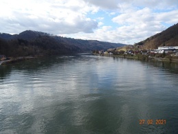
Loop of Schlögen, UA. State Museum, Paschinger Hügl rest area, Danube, wonderful forest landscape
Equipment:
Hiking backpack (incl. rain cover), sturdy shoes
Starting point: Waldkirchen am Wesen
Destination: Waldkirchen am Wesen
further information:
- Flatly
- Board possible
Accessibility / arrival
Parking
Parking possibilities
Public Transit
Location and getting there
How to arrive in the Danube Upper Austrian region?
The fast way to your destination – by train, bus, car, boat or plane.
Parking
Parking possibilities
Most economical season
- Spring
- Summer
- Autumn
- Early winter
Please get in touch for more information.
Waldkirchen 61
4085 Waldkirchen am Wesen
Phone +43 7718 7255
E-Mail gemeinde@waldkirchen.ooe.gv.at
Web www.donauregion.at/waldkirchen
https://www.donauregion.at/waldkirchen
Interactive elevation profile
Create PDF
Tour-Details
Starting place: 4085 Waldkirchen am Wesen
Destination: 4085 Waldkirchen am Wesen
duration: 4h 24m
length: 14,9 km
Altitude difference (uphill): 521m
Altitude difference (downhill): 522m
Lowest point: 285m
Highest point: 610m
difficulty: medium
condition: medium
panoramic view: Dreamtour
Paths covering:
Asphalt, Other
powered by TOURDATA | Suggest a change
Suggest changes
Please let us know how we can improve the quality of this object or if there is any incorrect information on this page (eg. opening hours, contact, etc.).
Please fill in all fields marked *.