


Hindinger Panorama-circular path


- Suitable for families
- Flatly
Interactive elevation profile
Create PDF
Tour-Details
Starting place: 4785 Freinberg
Destination: 4785 Freinberg
duration: 0h 30m
length: 1,9 km
Altitude difference (uphill): 11m
Altitude difference (downhill): 11m
Lowest point: 424m
Highest point: 440m
difficulty: easy
condition: very easy
panoramic view: Dreamtour
Paths covering:
Asphalt, Other
powered by TOURDATA | Suggest a change
Short description:
Short paved circular path starting at the parking lot of Restaurant Blaas
Short paved circular path starting at the parking lot of Restaurant Blaas
Technique: *
Quality of experience: *
Recommended season:
- January
- February
- March
- April
- May
- June
- July
- August
- September
- October
- November
- December
Properties:
- Loop
- Scenic
- Refreshment stops available
- Family friendly
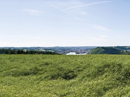
Paved circular path starting at parking lot of Blaas panoramic restaurant. From below the restaurant you'll have unforgettable views of the entire old quarter with the tri-river mouth of Passau. After a short distance on the path you can enjoy fabulous views into Danube Valley and the towns and villages of the Bavarian forest on the opposite side.
Tip:
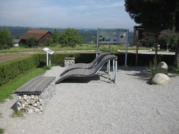
Stop off and enjoy some treats in Cafe-Restaurant Blaas
Equipment:
Hiking backpack (incl. rain cover), sturdy shoes
Starting point: Parking lot Blaas
Destination: Parking lot Blaas
further information:
- Flatly
- Board possible
Accessibility / arrival
Parking
parking place Blaas
Public Transit
Location and getting there
How to arrive in the Danube Upper Austrian region?
The fast way to your destination – by train, bus, car, boat or plane.
Parking
parking place Blaas
Most economical season
- Spring
- Summer
- Autumn
- Early winter
- Deep winter
Please get in touch for more information.
Freinberg 4
4785 Freinberg
Phone +43 7713 8102 - 0
E-Mail gemeinde@freinberg.ooe.gv.at
Web www.freinberg.at
https://www.freinberg.at
Interactive elevation profile
Create PDF
Tour-Details
Starting place: 4785 Freinberg
Destination: 4785 Freinberg
duration: 0h 30m
length: 1,9 km
Altitude difference (uphill): 11m
Altitude difference (downhill): 11m
Lowest point: 424m
Highest point: 440m
difficulty: easy
condition: very easy
panoramic view: Dreamtour
Paths covering:
Asphalt, Other
powered by TOURDATA | Suggest a change
Suggest changes
Please let us know how we can improve the quality of this object or if there is any incorrect information on this page (eg. opening hours, contact, etc.).
Please fill in all fields marked *.