


Panoramic trail


- Suitable for families
- culturally interesting
- Flatly
Interactive elevation profile
Create PDF
Tour-Details
Starting place: 4141 Pfarrkirchen im Mühlkreis
Destination: 4141 Pfarrkirchen im Mühlkreis
duration: 2h 9m
length: 7,5 km
Altitude difference (uphill): 224m
Altitude difference (downhill): 227m
Lowest point: 699m
Highest point: 842m
difficulty: easy
condition: easy
panoramic view: Dreamtour
Paths covering:
Asphalt, Other
powered by TOURDATA | Suggest a change
Short description:
A short hike around Pfarrkirchen with fantastic, clear views
A short hike around Pfarrkirchen with fantastic, clear views
Technique: **
Quality of experience: ******
Recommended season:
- January
- February
- March
- April
- May
- June
- July
- August
- September
- October
- November
- December
Properties:
- Loop
- Scenic
- Refreshment stops available
- Family friendly
- Cultural/historical value
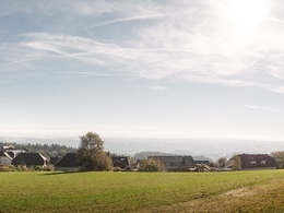
The hike at first leads from the village centre up to Platte hill, where you`ll find the viewing platform "Panoramablick". From here you have superb panoramic views from Ötscher across Dachstein Mountains and all the way to the Tyrolean Limestone Alps. Then we`ll walk along forest and meadow paths through the wonderful scenery around Pfarrkirchen. We`ll only encounter a few minor uphill and downhill climbs along the way. Altogether, the trail is easy to negotiate for all hiking fans. For a fair bit, we follow the butterfly hiking trail on which you can learn more about nature and the municipality at 21 stations.
Equipment:
no special equipment required
Additional information:
Baroque parish church parish churches with original paintings by Carlone (1697)
Starting point: Town center Pfarrkirchen
Destination: Town center Pfarrkirchen
further information:
- Flatly
- Board possible
Accessibility / arrival
Parking
In the village
Public Transit
Location and getting there
How to arrive in the Danube Upper Austrian region?
The fast way to your destination – by train, bus, car, boat or plane.
Bus stop village centre
Parking
In the village
Most economical season
- Spring
- Summer
- Autumn
- Early winter
- Deep winter
Please get in touch for more information.
Pfarrkirchen Nr. 13
4141 Pfarrkirchen im Mühlkreis
Phone +43 7285 415
Fax machine +43 7285 415 - 4
E-Mail pfarrkirchen@oberoesterreich.at
Web www.donauregion.at/pfarrkirchen
https://www.donauregion.at/pfarrkirchen
Interactive elevation profile
Create PDF
Tour-Details
Starting place: 4141 Pfarrkirchen im Mühlkreis
Destination: 4141 Pfarrkirchen im Mühlkreis
duration: 2h 9m
length: 7,5 km
Altitude difference (uphill): 224m
Altitude difference (downhill): 227m
Lowest point: 699m
Highest point: 842m
difficulty: easy
condition: easy
panoramic view: Dreamtour
Paths covering:
Asphalt, Other
powered by TOURDATA | Suggest a change
Suggest changes
Please let us know how we can improve the quality of this object or if there is any incorrect information on this page (eg. opening hours, contact, etc.).
Please fill in all fields marked *.