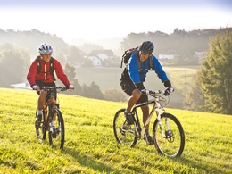
MTB - Rodltal tour
The loop leads up to panoramic heights and through five river valleys. You can start with parking in Walding at the sports park or in St. Gotthard at the Musikheim. You can also join the E1 variant at the Rottenegg sports field.
Recommended seasons:
- April
- May
- June
- July
- August
- September
- October
- round tour
- with great views
From the Walding Sports Park, the Rodltal circuit leads past the Walding Zoo to the Mursberg, until a short single trail leads down to the Saurüsselbach and over the Oberstraßer Höhenrücken to the idyllic Eschelbach, where you meet the connection to the Granitlandrunde or Hansbergland-Südrunde. Further along the loop, the beautiful onion dome of St. Gotthard church soon comes into view. From the valley of the Kleine Rodl, the route leads up to Limberg, where you can enjoy a breathtaking view of the Danube valley and the Alps, before descending in serpentines to the Große Rodl, where you can easily let your bike run to Rottenegg. But while still in the village, the route leads up to the next viewing point at Jörgensbühl and finally along the Brandstätterbach stream back to Walding Sports Park.
Variant E1 leads from the parking lot in Rottenegg Sportplatzstraße via the old stone-paved trade route, the Krumauer Reichsstraße, to the Oberstraßer Höhenrücken and joins the Rodltalrunde E. If you finish this in Rottenegg, you are back at the starting point of variant E1.
- Spring
- Summer
- Autumn
Please get in touch for more information.
Lindengasse 9
4040 Linz
Phone +43 732 7277 - 800
Fax machine +43 732 7277 - 804
E-Mail info@donauregion.at
Web www.donauregion.at
Suggest changes
Please let us know how we can improve the quality of this object or if there is any incorrect information on this page (eg. opening hours, contact, etc.).
Please fill in all fields marked *.


