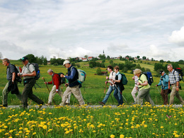
Europäischer Pilgerweg Via Nova
Starting place: 4780 Schärding
Destination: 5351 Strobl
From Mallersdorf/Pfaffenberg (D) to Lake Wolfgangsee (A)
There are two route variants, one leads via the Bavarian Klosterwinkel and crosses the Inn at Ering/Frauenstein. The second variant runs via Passau, Wernstein am Inn, Schärding and the Upper Austrian Hausruck towards the Salzburg lake district. Starting place: 4780 Schärding
Destination: 5351 Strobl
duration: 5h 30m
length: 19,9 km
Altitude difference (uphill): 328m
Altitude difference (downhill): 340m
Lowest point: 305m
Highest point: 552m
difficulty: easy
condition: easy
panoramic view: Great panorama
Paths covering:
Asphalt, Gravel, Street
further information:
- Multi-day tour
- Possible accommodation
Details - hiking
- themed path
Most economical season
- Spring
- Summer
- Autumn
Please get in touch for more information.
Innbruckstraße 29
4780 Schärding
Phone +43 7712 4300 - 0
Fax machine +43 7712 4320
E-Mail info@schaerding.info
Web www.schaerding.at/
Web www.pilgerweg-vianova.eu/
https://www.schaerding.at/
https://www.pilgerweg-vianova.eu/
https://www.pilgerweg-vianova.eu/
Suggest changes
Please let us know how we can improve the quality of this object or if there is any incorrect information on this page (eg. opening hours, contact, etc.).
Please fill in all fields marked *.


