Kößlbach-Wanderung
Path number: 12 - Wanderweg
Starting place: 4725 St. Aegidi
Destination: 4725 St. Aegidi
St. Aegidi 10
4725 St. Aegidi
4725 St. Aegidi

This hiking trail has trail number 12.
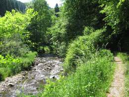
The hike around the Kleine Kößlbach nature reserve starts at the inn in Frauendorf and leads opposite the inn in the direction of Mittelbach. The path turns right here. Cross meadows to reach the nature reserve. Once in the forest, it is worth taking a detour to the Burgstall ruins (200 m) with a marvellous view of the Kößlbach valley. Return along the same path, then turn right to St Pankraz Chapel. From there, the trail continues uphill for a short distance and then descends to the Danube.The Kößlbach is crossed and the Kößlbachweg leads gently uphill through the wooded Kößlbachleiten. The view down to the foaming Kößlbach stream becomes more attractive with every step. The path leads through forest and rocky landscapes to a farm. Continue along the "Rabauerweg" towards Atzersdorf with a panoramic view of the four quarters of the country. From Atzersdorf, the route leads via Rabauer to Sittling. From the wooden bridge over the Kößlbach, the trail climbs uphill to Adelsgrub, then turns right along a meadow path, briefly through a wooded area and onwards through fields along the Roßgattern road to Dorf and back to the starting point.
- Suitable for groups
- Suitable for kids (10 - 14 Year)
- Suitable for single travelers
- Suitable for families
- Suitable for friends
- Suitable for couples
- Spring
- Summer
- Autumn
Please get in touch for more information.
St. Aegidi 10
4725 St. Aegidi
Phone +43 7717 7355
Fax machine +43 7717 7355 - 4
E-Mail gemeinde@st-aegidi.ooe.gv.at
Web www.st-aegidi.at
http://www.st-aegidi.at
Suggest changes
Please let us know how we can improve the quality of this object or if there is any incorrect information on this page (eg. opening hours, contact, etc.).
Fields marked with an asterisk (*) are obligatory


