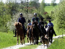
Reitweg Andorf
Starting place: 4770 Andorf
Destination: 4755 Zell an der Pram
Starting from the R 1, the R 2 branches off in the village of Seifriedsedt and continues to the Island Pferdehof Schlederer in Lichtegg. From there it continues to the municipalities of Raab and Zell an der Pram.
Tip: We will be happy to send you our map with all the bridleways in Andorf.
Tip: We will be happy to send you our map with all the bridleways in Andorf.
Most economical season
- Spring
- Summer
- Autumn
- Early winter
Please get in touch for more information.
Haupstraße 32
4770 Andorf
Phone +43 7766 2255 - 15
E-Mail tourismus@andorf.ooe.gv.at
Web www.tourismus-andorf.at/andorf/
http://www.tourismus-andorf.at/andorf/
Suggest changes
Please let us know how we can improve the quality of this object or if there is any incorrect information on this page (eg. opening hours, contact, etc.).
Please fill in all fields marked *.


