R3 Innviertler Panorama- und Museumstour
Starting place: 4770 Andorf
Destination: 4770 Andorf
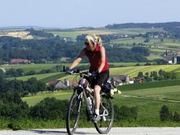
Starting in Andorf and continuing in a south-easterly direction, you cycle through the charming natural landscape over the ridge (Humerleiten to Breitenberg), past the Wetterkreuz and through the listed farming village of Blindendorf. Then you cycle westwards through the Celtic Golf Course Schärding to the Taufkirchen museums and along the Pram back to Andorf. This route is particularly suitable for families.
Total length: 42 km
Signposting: R9
Tip: Visit the Taufkirchen museums (Laufenbach Craft Museum & Bilger-Breustedt House)
Total length: 42 km
Signposting: R9
Tip: Visit the Taufkirchen museums (Laufenbach Craft Museum & Bilger-Breustedt House)
Most economical season
- Spring
- Summer
- Autumn
Please get in touch for more information.
Hauptstraße 32
4770 Andorf
Phone +43 7766 2255 - 15
E-Mail tourismus@andorf.ooe.gv.at
Web www.tourismus-andorf.at
http://www.tourismus-andorf.at
Suggest changes
Please let us know how we can improve the quality of this object or if there is any incorrect information on this page (eg. opening hours, contact, etc.).
Please fill in all fields marked *.


