Naturerlebnisweg
Starting place: 4724 Neukirchen am Walde
Destination: 4724 Neukirchen am Walde
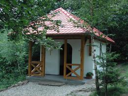
The starting point for the hike on the nature experience trail is the market square by the statue of St John Nepomuk (next to the "Gasthaus zur Post"). The signposted trail first leads along a stretch of tarmac between residential houses and farm buildings past the Kreuzberg Chapel to the signposted junction in Salling. There, turn right onto the adventure trail in the open countryside. You pass a "Celtic tree circle" and hikers can take a quiet break at the Ölbründel chapel.
The circular trail is around 3.5 kilometres long and can be hiked in around an hour. It can be easily walked by anyone.
Children can let off steam at various play stations (climbing tree, balance beam, tree seesaw and balance snake).
The circular trail is around 3.5 kilometres long and can be hiked in around an hour. It can be easily walked by anyone.
Children can let off steam at various play stations (climbing tree, balance beam, tree seesaw and balance snake).
Most economical season
- Spring
- Summer
- Autumn
Please get in touch for more information.
4724 Neukirchen am Walde
Phone +43 7278 3255
Fax machine +43 7278 3255 - 2
E-Mail gemeinde@neukirchen-walde.ooe.gv.at
Web www.neukirchen-walde.ooe.gv.at
http://www.neukirchen-walde.ooe.gv.at
Suggest changes
Please let us know how we can improve the quality of this object or if there is any incorrect information on this page (eg. opening hours, contact, etc.).
Please fill in all fields marked *.


