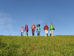
Frühlingswanderung im Donautal
Starting place: 4090 St. Aegidi
Destination: 4090 St. Aegidi
Snow lilies in the mountains, snowdrops in the Danube valley - spring blossoming begins differently depending on the region.
In search of the first harbingers of spring, we hiked from Engelhartszell to the highest point in the Sauwald, the Haugstein.We chose Engelszell Abbey as our starting point - partly because of the opportunity to replenish our stocks of flavoursome herbal liqueurs. Follow Pfarrstraße, turn into Bundesstraße 136 and at the first hairpin bend the trail begins with signs for the trout circus. The route quickly climbs steadily. Not far before St. Aegidi, you reach the road again, cross it, follow the access road to the Pamingerhof and pass through the small village of Zimmerleithen in a wooded area to the Forellenzirkus turn-off.
The small mill with the little stream in which trout perform all kinds of tricks can be reached in 15 minutes.
in 15 minutes. This little detour brings back memories of childhood Sunday outings to the "tame trout". From the junction, continue along the road through the village of Schöfberg. Shortly afterwards, you turn into a meadow path and, with a view of the Haugstein, you hike down into a hollow and up to the Tomandl snack station. The small village of Stadl with its eye-catching neo-Gothic church is not far away. Along the Way of the Cross, which is well worth seeing with its massive granite stone stations, you make a pilgrimage up to the Jagabild Chapel. The highest peak in the Innviertel region, the Haugstein with its massive rock formations, is a lovely place for a rest. Back at the chapel, follow the forest road down to the ski lift. Shortly before reaching the ski lift, turn onto another forest road and descend slightly to a road which you follow for another 500 metres. Here you will find the signs for the Donau Höhenweg and this leads through the beautiful landscape back down into the Danube valley to Engelhartszell. By the way, we discovered snowdrops, but only at the very end of this hike.
How to get there:
on the B 130 along the Danube
Characteristics:
Varied, longer hike on mostly marked paths, very scenic in spring when the trees still allow you to see through, no particular difficulties
Refreshments:
Tomandl snack station with fish specialities, inns in Stadl and Engelhartszell
Maps:
Compass No. 201
Internet:
www.donaunatur.com
www.engelhartszell.at
Book tip:
Neuweg/Peham: Hiking in Upper Austria. OÖN by Trauner Verlag, Linz 2008
Most economical season
- Spring
- Summer
- Autumn
Please get in touch for more information.
St. Aegidi 10
4090 St. Aegidi
Phone +43 7717 7355 - 0
Fax machine +43 7717 7355 - 4
E-Mail gemeinde@st-aegidi.ooe.gv.at
Web www.st-aegidi.at
https://www.st-aegidi.at
Suggest changes
Please let us know how we can improve the quality of this object or if there is any incorrect information on this page (eg. opening hours, contact, etc.).
Fields marked with an asterisk (*) are obligatory


