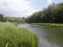
Aulandschaft im Machland Nord
Saxen, Oberösterreich, Österreich
The suggested area of the European protected area “Machland Nord” extends from the power station Wallsee-Mitterkirchen in the west to the borders of the Danube near Hirschenau. In the south, the frontiers to Lower Austria form the borders. In the north, the eastern part is defined by the northern Danube banks and near Dornach the terrace edge to the lower terrace forms the borders.
Approaching the power station Wallsee-Mitterkirchen, the „Hüttinger Arm“ is the northern border of the area.
4351 Saxen
Phone +43 650 3157223
E-Mail entenlacke@drei.at
Web www.entenlacke.at
http://www.entenlacke.at
Contact person
Naturschutzbund Regionalgruppe Machland
Saxen 8
4351 Saxen
Phone +43 650 3157223
E-Mail entenlacke@drei.at
Web www.entenlacke.at
Please get in touch for more information.
Suggest changes
Please let us know how we can improve the quality of this object or if there is any incorrect information on this page (eg. opening hours, contact, etc.).
Fields marked with an asterisk (*) are obligatory


