
R1.05 Sauwald Panorama Route


4040 Linz

"Sauwald – Cycling with grandeur and Alpine views"
Recommended season:
- March
- April
- May
- June
- July
- August
- September
- October
- Loop
- Scenic
- Refreshment stops available
- Family friendly
- Geological highlights
Great highland cycling route over the rural Sauwald high plateau. The rugged highland south of the Upper Danube valley fascinates with mystical forests, a mosaic of fields and meadows, traditional farm hamlets, rolling landscape … and seemingly endless views. The first half leads through hilly landscape, the second over a panoramic high ridge.
Highlights:
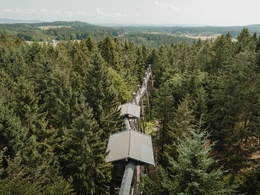
- Treetop Path Kopfing (world's longest treetop path, nature experience world)
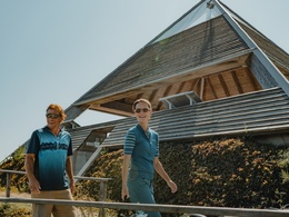
- Meditation pyramid on the Etzinger hill (architectural highlight, Alpine view)
- Sauwald Panorama Road (staged panoramic viewpoints)
- IKUNA Nature Resort and Nature Adventure Park
- Four-quarters View (panoramic view over the four quarters of Upper Austria)
A worthy starting point for this contrasting cycling round over the Sauwald high plateau is the Treetop Path Kopfing. Situated on a forest hill, the unusual perspective from the treetops lets you experience the vastness and beauty of the high plateau. Simply breathtaking! From the forest hill, you cycle down farmer’s roads into the charming elevated village of Kopfing – a typical clustered village of Sauwald! In the harsh climate, the land had to provide food; considerations about village appearance were secondary.
On Kopfing street, you climb hilly towards Entholz. Shortly after, you enter the mystical forests of Sauwald. Almost flat forest paths lead through magnificent mixed forest past the legendary Jungfraustein – a rocking stone and ancient cult site! Here you can atmospherically trace the original (Sau)wald landscape. Afterwards, you cycle leisurely on lonely side roads gently downhill through the extensive Hörzinger forest, softly hilly. Rural oases amid the forest sea recall the strenuous land cultivation. Towards the valley, lush meadows, fertile fields, scattered farms, and small woods dominate the route – pure Sauwald countryside idyll!
From Reiting, 2 km of a brisk descent to Natternbach provide a speed rush. The pleasant market town – also a clustered village – played a key role in the Upper Austrian Peasants’ War. The high elevation and beauty of Sauwald explain the proud self-consciousness of the locals. A short ascent to a plateau, then through a mosaic of fields to Neukirchen am Walde. The archetypal marketplace tells of historical importance; the former Spättenbrunn castle of medieval lordship. From the plateau, a 2.4 km delighting descent leads down to Willing, the lowest point (391 m) of the route! Through the steep forest gorge of the forest stream, the road quickly climbs opposite. In Hofstetten, the toughest part is done: you cycle gently hilly over lonely farmland – partly along natural field paths – upwards to the elevated village of St. Agatha.
Now begins the sublime ride over the roof of Sauwald! On gentle agricultural roads, you cycle over a hilly panoramic high ridge. A magnificent start is the imposing Etzinger meditation pyramid (642 m). Congratulations, you are at the highest point of the route! Afterwards, wonderful Sauwald farmland and breathtaking wide views into the Mühlviertel, over the Alpine foothills to the Alps captivate … pure bliss! After a short gorge, you reach Waldkirchen am Wesen on the next high ridge. The Sauwald high plateau presents itself once more from its most beautiful side. A highlight: the short detour to the extraordinary Four-quarters View. The 360° panoramic view allows limitless vistas into all four quarters of Upper Austria! A short regeneration descent takes you into the Waldgraben of Sittling. Then follows a 4.5 km ascent over a mountain ridge. Idyllic Sauwald farmland enchants, with increasing height the view expands. In St. Aegidi, you stand at the highest point of the third high ridge. Congratulations! After the altitude flight, the hilly descent through hidden valley folds provides relaxation. From Voglgrub begins the last ascent through rolling farmland and ancient (Sau)wald to the treetop path. Highland cycling – a (high) pleasure!
Tip:Discovery journeys with a delightful stopover! This route passes directly by the following culinary partners:
Safety guidelines:
The majority of this highland cycling route uses quiet (side) streets and paved agricultural roads. In the Jungfraustein area, the route goes 1.5 km and before the treetop path 800 m over forest paths. Natural field paths are present before Hofstetten (600 m) and around Hausleithen (900 m, 800 m). Therefore, this route is hardly suitable for racing bikes. Basic gear shifting skills are advantageous for the uphill sections. Basic braking skills are necessary for the downhill sections.
Signposting:
To make orientation easier, the Danube cycling rounds have been marked with their own cycling navigation system. This route follows the signage "R1.05 Sauwald Panorama Route".
Paths covering:
further information:
- Flatly
- Board possible
")
")
")
")
")
Public Transit
How to arrive in the Upper Austria Danube region?
The fastest way to your destination – by train, bus, car, ship, or airplane.
- Spring
- Summer
- Autumn
Please get in touch for more information.
Lindengasse 9
4040 Linz
Phone +43 732 7277 - 800
Fax machine +43 732 7277 - 804
E-Mail info@donauregion.at
Web www.donauregion.at
Altitude profile - R1.05 Sauwald Panorama Route
Suggest changes
Please let us know how we can improve the quality of this object or if there is any incorrect information on this page (eg. opening hours, contact, etc.).
Please fill in all fields marked *.