
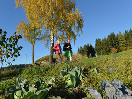
© Tourismusverband Donau Oberösterreich | Kuscheiart: Zwei Freundinnen genießen den wundervollen Ausblick von der Gobelwarte Grein.


Hoader-Steig Nr. 52


- Suitable for families
- Flatly
- Possible accommodation
Interactive elevation profile
Create PDF
Tour-Details
Starting place: 4272 Weitersfelden
Destination: 4272 Weitersfelden
duration: 1h 0m
length: 3,0 km
Altitude difference (uphill): 153m
Altitude difference (downhill): 158m
Lowest point: 744m
Highest point: 894m
difficulty: easy
condition: easy
panoramic view: Great panorama
Paths covering:
Asphalt, Hiking trail
powered by TOURDATA | Suggest a change
Hoader Steig No. 52
Starting point: The starting and finishing points are at the Weitersfelden municipal office
further information:
- Flatly
- Possible accommodation
- Board possible
The Hoader-Steig can be hiked at any time.
Accessibility / arrival
by car:
from Linz - A7 - Königswiesener Straße - Gutauer Straße to Weitersfelden
- Suitable for seniors
- Suitable for families
- Suitable for friends
- Suitable for couples
- Suitable for children
- Spring
- Summer
- Autumn
Please get in touch for more information.
Weitersfelden 11
4272 Weitersfelden
Phone +43 7952 6255
Fax machine +43 7952 6255 - 9
E-Mail gemeinde@weitersfelden.ooe.gv.at
Web www.weitersfelden.ooe.gv.at
http://www.weitersfelden.ooe.gv.at
Interactive elevation profile
Create PDF
Tour-Details
Starting place: 4272 Weitersfelden
Destination: 4272 Weitersfelden
duration: 1h 0m
length: 3,0 km
Altitude difference (uphill): 153m
Altitude difference (downhill): 158m
Lowest point: 744m
Highest point: 894m
difficulty: easy
condition: easy
panoramic view: Great panorama
Paths covering:
Asphalt, Hiking trail
powered by TOURDATA | Suggest a change
Hoader-Steig Nr. 52
Suggest changes
Please let us know how we can improve the quality of this object or if there is any incorrect information on this page (eg. opening hours, contact, etc.).
Please fill in all fields marked *.