


Haibach: CICONIA-Loop Trail


- Flatly
- Possible accommodation
Interactive elevation profile
Create PDF
Tour-Details
Paths covering:
Schlögen - Inzell - Steiner Felsen vantage point - Rotes Kreuz - Schlögener Blick vantage point – Schlögen
Recommended season:
- April
- May
- June
- July
- August
- September
- October
- Loop
- Scenic
- Geological highlights
- Botanical highlights
- Faunistic highlights
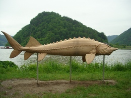
We hike along the approx. 10.5km-long CICONIA trail that features numerous stations and sculptures that tell about the unique landscape there.
Schlögen . Near the hotel complex is a excavation site datig back to the Romans (excavated west gate of the Ioviacum settlement that has been chartered around 440 A.D.). Our hike continues downstream the Danube along the Inzell carriage way to the village of of the same name, Inzell. There is the St. Nikolaus church that has been put under a protection order. We leave the carriage way just before it makes a left turn towards the Danube and take a right turn into the hiking trail. From there we continue along the Danauleiten uphill to the known “Steiner Felsen” vantage point. We follow the singposted hiking trail no. 55 through the wood-covered Donauleiten hills and get to the “Au” vantage point. From there we enjoy a nice view of the Danube loop. We follow the hiking trail and get to “Wohlfartner” farm. After some 500m we take a right turn into the marked hiking trail that leads into the forest (Rotes Kreuz) and to “Schlögener Blick” vantage point from where we enjoy a fantastic view of the well-known Danube loop. You can enjoy this fantastic view also from the livecam at http://www.oberoesterreich.at/haibach . From there we hike back to Schlögen.
Directions:We hike along the approx. 10.5 km long CICONIA adventure trail, which informs us about the special features of this unique landscape with numerous stations and sculptures and accompanies us from now on.
Along this circular trail, hikers can immerse themselves in the unique natural habitat of the Upper Danube with the help of information boards and adventure stations.Not far from the hotel complex is an archaeological site from Roman times (uncovered west gate of the river pioneer settlement of Ioviacum, mentioned around 440 AD). Opposite the hotel, we take the Ciconia path, which leads us to the famous ‘Schlögener Blick’ viewpoint after a 30-minute walk. This striking view of the Danube Loop was voted a natural wonder of Upper Austria. We continue to follow the ‘Ciconia Weg’ markings, emerge from the forest at the Red Cross and turn left onto the path to Linetshub. Passing ponds, we reach the Linetshub goods road, turn left and, after a short stretch of tarmac road, turn left again onto the hiking trail. We reach the Au viewpoint. Here we again have a beautiful view of the Danube loop. The path now leads through woods and meadows along the Donauleiten to the famous ‘Steiner Felsen’ viewpoint. We continue along the ridge and reach the village of Inzell after a descent. Here you will find the listed St Nicholas Church. We now follow the Inzell goods road up the Danube and reach the village of Inzell after 4 kilometres.
Tip:Zum höchsten Aussichtspunkt im Gemeindegebiet (563 m) führt der Kalvarienbergweg. Bei guter Fernsicht hat man von der Kalvarienberg-Kapelle einen Blick vom Mühlviertel bis zum Dachsteinmassiv. Diese einzigartige Landschaft lädt ein, bis zur Ruine Stauf weiter zu wandern.Equipment:
Wanderrucksack (inkl. Regenhülle), festes SchuhwerkAdditional information:
Haibach ob der Donau Tourist Board
4083 Haibach 40
Tel.: 0043(0)7279/8235
Fax: 0043(0)7279/8235-16
E-mail: haibach@oberoestereich.at
www.haibach-donau.at
further information:
- Flatly
- Possible accommodation
Details - hiking
- themed path
- educational path
")


")

")
")
")

")
")
Getting there
By car: Westautobahn, “Linz” or “Wels” exit, towards Eferding, on the B130 towards Passau
By train: Linz or Wels main station, continue by bus towards Eferding – Haibach or Passau main station, by bus towards Linz
By plane: Linz/Hörsching airport
By boat: Schlögen boat landing stage
Public Transitwww.donauregion.at/en/service/getting-there-mobilityParking
Large car park at the Hotel Donauschlinge
- Suitable for single travelers
- Suitable for friends
- Suitable for couples
- Spring
- Summer
- Autumn
Please get in touch for more information.
Kirchenplatz 4
4083 Haibach ob der Donau
mobile 677 61621401
E-Mail haibach@oberoestereich.at
Web www.donauregion.at/haibach
Web www.donauregion.at
http://www.donauregion.at
")
Interactive elevation profile
Create PDF
Tour-Details
Paths covering:
Haibach: CICONIA-Loop Trail
Suggest changes
Please let us know how we can improve the quality of this object or if there is any incorrect information on this page (eg. opening hours, contact, etc.).
Please fill in all fields marked *.