


Kopfwehstein Trail - E7


- Suitable for families
- Flatly
Interactive elevation profile
Create PDF
Tour-Details
Starting place: 4201 Eidenberg
Destination: 4201 Eidenberg
duration: 2h 19m
length: 8,0 km
Altitude difference (uphill): 246m
Altitude difference (downhill): 246m
Lowest point: 683m
Highest point: 895m
difficulty: medium
condition: medium
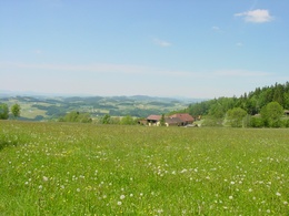
panoramic view: Great panorama
Paths covering:
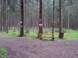
Asphalt, Path / trail, Street, Hiking trail
powered by TOURDATA | Suggest a change
Short description:
Starting point: Eidenberg localsquare - Gressn - Rotes Kreuz - Schönangerkapelle - Kohler - Wolfgang Chapel with Kopfwehstein - back to Kohler - Vorderpoitner (Lamahof) - Oberheberger - Eidenberger Alm - Eidenberg local square
Starting point: Eidenberg localsquare - Gressn - Rotes Kreuz - Schönangerkapelle - Kohler - Wolfgang Chapel with Kopfwehstein - back to Kohler - Vorderpoitner (Lamahof) - Oberheberger - Eidenberger Alm - Eidenberg local square
Quality of experience: ****
Recommended season:
- January
- February
- March
- April
- May
- June
- July
- August
- September
- October
- November
- December
Properties:
- Loop
- Scenic
- Refreshment stops available
- Family friendly
A hiking trail with interesting points, leading along a spectacular route through the Eidenberg high forest. It goes uphill at the beginning and after a long flat stretch it is all downhill. Magnificent panoramic views can be found along this trail.
Tip:
Eidenberg parish church, Red Cross - Schönanger Chapel, Kopfwehstein, Wolfgang Chapel
Equipment:
Hiking backpack (incl. rain cover), sturdy shoes
Starting point: municipal square Eidenberg
Destination: municipal square Eidenberg
further information:
- Flatly
- Board possible
Accessibility / arrival
Parking
municipal square Eidenberg
Public Transit
Location and getting there
How to arrive in the Danube Upper Austrian region?
The fast way to your destination – by train, bus, car, boat or plane.
From Linz OÖVV
Parking
municipal square Eidenberg
Most economical season
- Spring
- Summer
- Autumn
- Early winter
- Deep winter
Please get in touch for more information.
Stiftsstraße 2
4201 Eidenberg
Phone +43 7239 5279
E-Mail gemeinde@eidenberg.ooe.gv.at
Web www.eidenberg.ooe.gv.at
https://www.eidenberg.ooe.gv.at
Interactive elevation profile
Create PDF
Tour-Details
Starting place: 4201 Eidenberg
Destination: 4201 Eidenberg
duration: 2h 19m
length: 8,0 km
Altitude difference (uphill): 246m
Altitude difference (downhill): 246m
Lowest point: 683m
Highest point: 895m
difficulty: medium
condition: medium
panoramic view: Great panorama
Paths covering:
Asphalt, Path / trail, Street, Hiking trail
powered by TOURDATA | Suggest a change
Suggest changes
Please let us know how we can improve the quality of this object or if there is any incorrect information on this page (eg. opening hours, contact, etc.).
Please fill in all fields marked *.