


My way to myself


- pets allowed
- All weather
- Suitable for kids (all ages)
Interactive elevation profile
Create PDF
Tour-Details
Starting place: 4084 St. Agatha
Destination: 4084 St. Agatha
duration: 1h 54m
length: 7,0 km
Altitude difference (uphill): 149m
Altitude difference (downhill): 149m
Lowest point: 571m
Highest point: 640m
difficulty: easy
condition: very easy
panoramic view: Dreamtour
powered by TOURDATA | Suggest a change
Short description:
Easy hiking route with gentle climb at Etzinger Hill
Easy hiking route with gentle climb at Etzinger Hill
Technique: *
Quality of experience: ******
Recommended season:
- March
- April
- May
- June
- July
- August
- September
- October
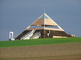
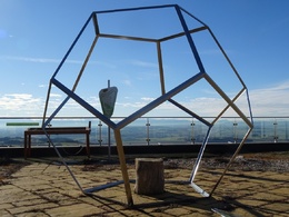
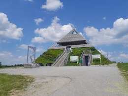
A hiking route That is easy to walk with a gentle climb at Etzinger Hill. Here you can hear the Me-meditation.-St. Agatha-Etzinger Hügel-Dörfledt-Scharzeredt-St. Agatha, the approx. The hiking-effect-path is an open journey of discovery. Be prepared for all surprises during your journey from station to station.
Tip:
Take your time, at least 2, even better 3 hours, because this trail first leads across deceleration to more ME-strength and thus more presence in life !
Equipment:
Hiking backpack (incl. rain cover), sturdy shoes
Starting point: St. Agatha, Revita Hotel
Destination: St. Agatha, Revita Hotel
Details - hiking
- themed path
Accessibility / arrival
Parking
Parking possibilities
Public Transit
Location and getting there
How to arrive in the Danube Upper Austrian region?
The fast way to your destination – by train, bus, car, boat or plane.
Parking
Parking possibilities
- All weather
- Suitable for groups
- Suitable for schools
- Suitable for kids (all ages)
- Pets allowed
- Suitable for teenagers
- Suitable for seniors
- Suitable for single travelers
- Suitable for friends
- Suitable for couples
- Suitable for children
- Spring
- Summer
- Autumn
Please get in touch for more information.
Kirchenplatz 1
4083 St. Agatha
Phone +43 7277 8255 - 0
E-Mail gemeinde@st-agatha.ooe.gv.at
Web tourismus.st-agatha.at
https://tourismus.st-agatha.at
Interactive elevation profile
Create PDF
Tour-Details
Starting place: 4084 St. Agatha
Destination: 4084 St. Agatha
duration: 1h 54m
length: 7,0 km
Altitude difference (uphill): 149m
Altitude difference (downhill): 149m
Lowest point: 571m
Highest point: 640m
difficulty: easy
condition: very easy
panoramic view: Dreamtour
powered by TOURDATA | Suggest a change
Suggest changes
Please let us know how we can improve the quality of this object or if there is any incorrect information on this page (eg. opening hours, contact, etc.).
Please fill in all fields marked *.