


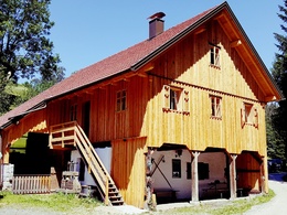
Hammer mill tour


- Suitable for families
- Suitable for pushchairs
- culturally interesting
Interactive elevation profile
Create PDF
Tour-Details
Path number: 111
Starting place: 4084 St. Agatha
Destination: 4084 St. Agatha
duration: 2h 39m
length: 9,7 km
Altitude difference (uphill): 212m
Altitude difference (downhill): 212m
Lowest point: 429m
Highest point: 640m
difficulty: medium
condition: medium
panoramic view: Great panorama
Paths covering:
Asphalt, Other
powered by TOURDATA | Suggest a change
Short description:
From the centre of St. Agatha, in its elevated position, the hike takes us to Risching. Heading south, the hiking trail continues to the idyllically located Hammer mill.
From the centre of St. Agatha, in its elevated position, the hike takes us to Risching. Heading south, the hiking trail continues to the idyllically located Hammer mill.
Technique: ***
Quality of experience: ****
Recommended season:
- March
- April
- May
- June
- July
- August
- September
- October
- November
Properties:
- Refreshment stops available
- Family friendly
- Cultural/historical value
- Suitable for strollers
Wonderful view into the Alpine foothills with the option of visiting the Hammer mill. St. Agatha-Riesching-Kolmhof-Gschwendt (Hammerschmiede) -Etzing-Scharzeredt-St. Agatha.
From the centre of St. Agatha, in its elevated position, the hike leads to Riesching. Heading south, the hiking trail continues to the idyllic Hammer mill
Tip:
Show-demonstration - mill
Starting point: St. Agatha center
Destination: St. Agatha center
further information:
- Board possible
Accessibility / arrival
Parking
Parking possibilities (also at Hammer mill)
Getting there
Yes
Public Transit
Location and getting there
How to arrive in the Danube Upper Austrian region?
The fast way to your destination – by train, bus, car, boat or plane.
Parking
Parking possibilities (also at Hammer mill)
- Suitable for pushchairs
- Spring
- Summer
- Autumn
- Early winter
Please get in touch for more information.
Kirchenplatz 1
4083 St. Agatha
Phone +43 7277 8255 - 0
E-Mail gemeinde@st-agatha.ooe.gv.at
Web tourismus.st-agatha.at
https://tourismus.st-agatha.at
Interactive elevation profile
Create PDF
Tour-Details
Path number: 111
Starting place: 4084 St. Agatha
Destination: 4084 St. Agatha
duration: 2h 39m
length: 9,7 km
Altitude difference (uphill): 212m
Altitude difference (downhill): 212m
Lowest point: 429m
Highest point: 640m
difficulty: medium
condition: medium
panoramic view: Great panorama
Paths covering:
Asphalt, Other
powered by TOURDATA | Suggest a change
Suggest changes
Please let us know how we can improve the quality of this object or if there is any incorrect information on this page (eg. opening hours, contact, etc.).
Please fill in all fields marked *.