Kneipp trail Oberkappel
4144 Oberkappel

At 6 Kneipp stations you can do something for your health.
Along the path also runs the Forest Wonder Trail. Signs along the way provide information about forest, water, and ground animals as well as plants.
Recommended season:
- March
- April
- May
- June
- July
- August
- September
- October
- November
- Loop
- Family friendly
- Botanical highlights
- Faunistic highlights
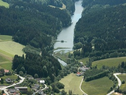
The Kneipp trail built along the Ranna reservoir is an attraction for young and old.
At 6 Kneipp stations you can do something refreshing for your health. Along the path also runs the Forest Wonder Trail. Signs along the way inform about forest, water, and ground animals as well as about plants and fruits. Another highlight is the pine cone throwing station. Here pine cones have to be thrown through a board with holes - the smaller the hole, the higher the score. The path ends at the Konzinger footbridge, a small wooden bridge. There you can either cross the reservoir and hike back on the other side or simply return the same way.
Sturdy footwearAdditional information:
https://www.donauregion.at/oberkappel/oesterreich-poi/detail/401586/kneipp--und-fitnessweg-rannatal.html
Paths covering:
further information:
- Flatly
Public Transit
How to get to the Upper Austria Danube Region?
The quick way to your destination – by train, bus, car, ship, or plane.
Bus stop in the town center
Parking
Municipal office, town center, fire station parking lot
- Spring
- Summer
- Autumn
- Early winter
Please get in touch for more information.
Marktstraße 4
4144 Oberkappel
Phone +43 7284 202 - 0
E-Mail marktgemeinde@oberkappel.ooe.gv.at
Web www.donauregion.at/oberkappel
Suggest changes
Please let us know how we can improve the quality of this object or if there is any incorrect information on this page (eg. opening hours, contact, etc.).
Please fill in all fields marked *.


