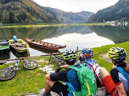
MTB - Mühl Valley Route
4113 St. Martin im Mühlkreis

Demanding day route with steep elevation gains and descents in the valleys of the Große and Kleine Mühl as well as the ridges in between.
Recommended season:
- April
- May
- June
- July
- August
- September
- October
- Loop
- Scenic
- Refreshment stops available
The MTB route starts at the village square of Kleinzell. Passing the natural swimming lake Resilacke, you ride to St. Martin, through the Mühlviertel hilly landscape down to the Danube at Untermühl. Into the valley of the Große Mühl, past the Partenstein reservoir power plant, steeply uphill to Ramersberg – a worthwhile detour to the pilgrimage church Maria Ramersberg – and then back down to the Große Mühl (Ebenmühle). 250 meters of elevation bring you up to Kirchberg and the Burgstall lookout tower. Descent to Obermühl at the confluence of the Kleine Mühl into the Danube, from where you ascend to Altenfelden and descend again to the village of Hühnergeschrei. From Arnreit along the Froschbach, you bike into the valley of the Große Mühl. Following the river downstream, you finally climb up to Etzerreit and descend to the Neufelden reservoir. A final tough climb to Apfelsbach then leads you back to the starting point Kleinzell.
further information:
- Flatly
- Board possible


- All weather
- Suitable for groups
- Suitable for seniors
- Suitable for single travelers
- Suitable for friends
- Suitable for couples
- Spring
- Summer
- Autumn
Please get in touch for more information.
Markt 2
4113 St. Martin im Mühlkreis
Phone +43 7232 2105
E-Mail gemeindeamt@sankt-martin.at
Web www.tourismus-sankt-martin.at
Suggest changes
Please let us know how we can improve the quality of this object or if there is any incorrect information on this page (eg. opening hours, contact, etc.).
Please fill in all fields marked *.


