


Mäusejagd auf der Via Scardinga


- pets allowed
- All weather
- Suitable for families
- Suitable for kids (all ages)
- Flatly
Interactive elevation profile
Create PDF
Tour-Details
Starting place: 4780 Schärding
Destination: 4780 Schärding
duration: 0h 27m
length: 1,8 km
Altitude difference (uphill): 10m
Altitude difference (downhill): 10m
Lowest point: 310m
Highest point: 323m
difficulty: easy
condition: easy
panoramic view: Some Views
Paths covering:
Asphalt, Gravel
powered by TOURDATA | Suggest a change
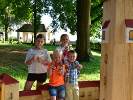
By the sea, in the mountains, around the world: in summer, we are drawn to unknown destinations and exciting adventures. A visit to the baroque town of Schärding shows that you can also find these on your own doorstep. The town organises a fun mouse hunt on the "Via Scardinga".
The main characters are blue mice made of wood, which are hidden at various stations along the "Via Scardinga". You have to count them, but you also have to pay close attention so that you know the right answer to all the questions in the mouse passport at the end. The information boards along the "Via Scardinga" provide the necessary information.
Bringing history to life
Fun and excitement are guaranteed along the way: trying on a knight's armour, posing at the pillory, playing (board) games in the castle park and many other attractions. The 22 stations of the exciting "Via Scardinga" bring the history of the town to life. Many of the stations are interactive and invite visitors to join in and try things out. Admission is free.
The Mouse Pass is available from the large start board on the town square, the tourist office, the town museum, Baumgartner Stadtwirt, Linzer Bäcker, Ristorante Garibaldi, Lachinger's Kitchen & Wine, Gelatissimo and "BARista". The completed mouse passport is presented at these locations after the mouse hunt. If everything is filled in correctly, you get a funny mouse sticker stuck in your passport, write your name and address on the name section, tear this section off the mouse passport and receive a "Scardy mouse" made of fabric in return.
further information:
- Flatly
Details - hiking
- themed path
- All weather
- Suitable for schools
- Suitable for kids (all ages)
- Pets allowed
- Suitable for teenagers
- Suitable for single travelers
- Suitable for children
- Spring
- Summer
- Autumn
Somewhat suitable for wheelchairs: Assistance is sometimes necessary. The measurements do not (fully) conform to the legally stipulated ÖNORM.
Innbruckstraße 29
4780 Schärding
Phone +43 7712 4300 - 0
E-Mail info@schaerding.info
Web www.schaerding.at
http://www.schaerding.at
Interactive elevation profile
Create PDF
Tour-Details
Starting place: 4780 Schärding
Destination: 4780 Schärding
duration: 0h 27m
length: 1,8 km
Altitude difference (uphill): 10m
Altitude difference (downhill): 10m
Lowest point: 310m
Highest point: 323m
difficulty: easy
condition: easy
panoramic view: Some Views
Paths covering:
Asphalt, Gravel
powered by TOURDATA | Suggest a change
Suggest changes
Please let us know how we can improve the quality of this object or if there is any incorrect information on this page (eg. opening hours, contact, etc.).
Please fill in all fields marked *.