


Stilles Tal - Forellen Rundweg


- Flatly
Interactive elevation profile
Create PDF
Tour-Details
Starting place: 4363 Pabneukirchen
Destination: 4363 Pabneukirchen
duration: 1h 9m
length: 3,6 km
Altitude difference (uphill): 134m
Altitude difference (downhill): 131m
Lowest point: 366m
Highest point: 485m
difficulty: easy
condition: easy
panoramic view: Individual Views
Paths covering:
Hiking trail
powered by TOURDATA | Suggest a change
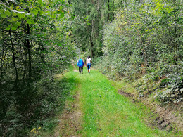
4b Stilles Tal - Trout circular trail (approx. 3,600 m)
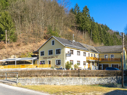
Starting point: GH "Zum Stillen Tal" You hike up the lovely Schurzmühlbach valley to the Schurzmühle mill (1,360), then uphill through the mixed forest to the Sigl chapel at the fork in the goods road (2,050 m). Beautiful vantage point with views of Unterdörfl to the east and Thomasreith to the west. The route climbs slightly to the left up the access road to Poldlberger and continues at a lofty height to Franzberger and Kranzler (2,930 m). Enjoy the marvellous panoramic view over the Thomastal valley before descending the forest path back to the inn.
Starting point: GH "Zum Stillen Tal" You hike up the lovely Schurzmühlbach valley to the Schurzmühle mill (1,360), then uphill through the mixed forest to the Sigl chapel at the fork in the goods road (2,050 m). Beautiful vantage point with views of Unterdörfl to the east and Thomasreith to the west. The route climbs slightly to the left up the access road to Poldlberger and continues at a lofty height to Franzberger and Kranzler (2,930 m). Enjoy the marvellous panoramic view over the Thomastal valley before descending the forest path back to the inn.
Most economical season
- Spring
- Summer
- Autumn
Please get in touch for more information.
Nr. 20a
4362 Bad Kreuzen
mobile +43 681 20583484
E-Mail info@gsundleben.at
Web www.gsundleben.at
Web www.bad-kreuzen.at
http://www.gsundleben.at
http://www.bad-kreuzen.at
http://www.bad-kreuzen.at
Interactive elevation profile
Create PDF
Tour-Details
Starting place: 4363 Pabneukirchen
Destination: 4363 Pabneukirchen
duration: 1h 9m
length: 3,6 km
Altitude difference (uphill): 134m
Altitude difference (downhill): 131m
Lowest point: 366m
Highest point: 485m
difficulty: easy
condition: easy
panoramic view: Individual Views
Paths covering:
Hiking trail
powered by TOURDATA | Suggest a change
Suggest changes
Please let us know how we can improve the quality of this object or if there is any incorrect information on this page (eg. opening hours, contact, etc.).
Please fill in all fields marked *.