


Ottensheim: Danube Panorama Trail


- Suitable for families
- culinary interesting
- Flatly
Interactive elevation profile
Create PDF
Tour-Details
Starting place: 4100 Ottensheim
Destination: 4100 Ottensheim
duration: 2h 30m
length: 8,2 km
Altitude difference (uphill): 227m
Altitude difference (downhill): 227m
Lowest point: 256m
Highest point: 483m
difficulty: easy
condition: easy
panoramic view: Dreamtour
Paths covering:
Asphalt, Path / trail, Gravel, Other
powered by TOURDATA | Suggest a change
Short description:
Wöginger - Dürnberg/Loislbauer - Niederottensheim - Ottensheim
Wöginger - Dürnberg/Loislbauer - Niederottensheim - Ottensheim
Technique: **
Quality of experience: ***
Recommended season:
- April
- May
- June
- July
- August
- September
- October
Properties:
- Loop
- Scenic
- Refreshment stops available
- Family friendly
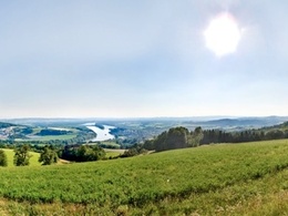
Starting place is the information point at the Ottensheim Danube ferry (Donaulände). Follow the signposts downstream to the Dürnberg boat landing place; continue then uphill in north-eastern direction to Kogleraugipfel summit. The route leads through the gentle hills of Dürnberg and offers breath-taking panoramic views of Danube Valley. After approximately two hours you get back to Marktplatz square with its numerous beer gardens.
Directions:
Startplatz beim Infopoint bei der Donaufähre Ottensheim (Donaulände). Über den Marktplatz und der Linzerstraße geht es nach Niederottensheim. Der Weg führt uns Richtung Dürnberg am Hochbehälter bis zu Kapelle beim Wöginger. Ab dort mit atemberaubendem Panoramablick vom Donautal bis ins Alpenvorland. Ab dem Nachfahrer geht es wieder bergab am Schröckinger vorbei bis zu GH Dürnbergwirt. Dem Treppelweg der Donau entlang folgend, erreichen wir wieder den Ausgangspunkt
Tip:
Tour of the oldest market municipality of Mühlviertel district - Ottensheim;
Ottensheim beer from the “Thor-Bräu” brewery at Marktplatz square
Equipment:
Hiking equipment
Additional information:
Ottensheim Tourist Board
Marktplatz 7
4100 Ottensheim
Telephone: +43 (0)7234 82255 30
Mobile: +43 (0)699 10437643
Fax: +43 (7234)82255 34
Email: ottensheim@oberoesterreich.at
www.oberoesterreich.at/ottensheim
Starting point: Ottensheim
Destination: Infopunkt bei der Donaufähre Ottensheim
further information:
- culinary interesting
- Flatly
- Board possible
")
")

")
")
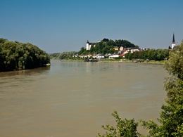
Ottensheim - 360°-Panoramafotos
")

Rastplatz Dürnberg
")

Startplatz Ottensheim
Startplatz Ottensheim
Rastplatz Dürnberg
Haltestelle Dürnberg (Bahn)
Accessibility / arrival
Public Transit
Mühlkreisbahn train www.oebb.at
Parking
Short-term parking zone at Donaulände; car parks at the Donauhalle/Ottensheim Stadium
Getting there
By car: B127 Donauuferstraße (10km west of Linz) to Ottensheim – across Marktplatz square of Ottensheim to the Danube ferry (starting place)
By train: Mühlkreisbahn train to Ottensheim train station or Dürnberg www.oebb.at
Cheap bus connections www.postbus.at
By boat: boat liners from Passau/Linz www.donauschiffahrt.de
Public Transit
Mühlkreisbahn train www.oebb.at
Parking
Short-term parking zone at Donaulände; car parks at the Donauhalle/Ottensheim Stadium
Most economical season
- Spring
- Summer
- Autumn
Please get in touch for more information.
Marktplatz 7
4100 Ottensheim
Phone +43 7234 82255 - 30
E-Mail ottensheim@oberoesterreich.at
Web www.ottensheim.info
Web www.donauregion.at
https://www.ottensheim.info
http://www.donauregion.at
http://www.donauregion.at
Interactive elevation profile
Create PDF
Tour-Details
Starting place: 4100 Ottensheim
Destination: 4100 Ottensheim
duration: 2h 30m
length: 8,2 km
Altitude difference (uphill): 227m
Altitude difference (downhill): 227m
Lowest point: 256m
Highest point: 483m
difficulty: easy
condition: easy
panoramic view: Dreamtour
Paths covering:
Asphalt, Path / trail, Gravel, Other
powered by TOURDATA | Suggest a change
Suggest changes
Please let us know how we can improve the quality of this object or if there is any incorrect information on this page (eg. opening hours, contact, etc.).
Please fill in all fields marked *.