


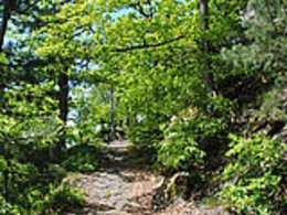
Haselmaus-Runde


- Suitable for families
- Flatly
Interactive elevation profile
Create PDF
Tour-Details
Path number: 4 - Nordic-Walking
Starting place: 4090 Engelhartszell
Destination: 4090 Engelhartszell
duration: 1h 1m
length: 3,7 km
Altitude difference (uphill): 65m
Altitude difference (downhill): 58m
Lowest point: 279m
Highest point: 345m
difficulty: easy
condition: easy
panoramic view: No view
Paths covering:
Hiking trail
powered by TOURDATA | Suggest a change
The hazel dormouse circuit has trail number 4.
Start at the Engelhartszell municipal office - past the parish church - uphill - before the end of the village turn left onto the meadow path to the Mühlbach stream - at the height of the monastery turn right into the monastery forest - dormouse - over the rushing stream in Saag - down to the main road - continue left - along the edge of the forest towards the monastery - at Gasthof Steininger through the subway - at the Wurm & Noé boat landing stage turn left up to the B 130 - back to the Engelhartszell municipal office.
Start at the Engelhartszell municipal office - past the parish church - uphill - before the end of the village turn left onto the meadow path to the Mühlbach stream - at the height of the monastery turn right into the monastery forest - dormouse - over the rushing stream in Saag - down to the main road - continue left - along the edge of the forest towards the monastery - at Gasthof Steininger through the subway - at the Wurm & Noé boat landing stage turn left up to the B 130 - back to the Engelhartszell municipal office.
- Suitable for groups
- Suitable for schools
- Suitable for kids (3 - 10 Year)
- Suitable for single travelers
- Suitable for friends
- Suitable for couples
- Suitable for children
- Spring
- Summer
- Autumn
Please get in touch for more information.
Marktplatz 61
4090 Engelhartszell
Phone +43 7717 8055 - 16
E-Mail tourismus@engelhartszell.ooe.gv.at
Web www.engelhartszell.at
https://www.engelhartszell.at
Interactive elevation profile
Create PDF
Tour-Details
Path number: 4 - Nordic-Walking
Starting place: 4090 Engelhartszell
Destination: 4090 Engelhartszell
duration: 1h 1m
length: 3,7 km
Altitude difference (uphill): 65m
Altitude difference (downhill): 58m
Lowest point: 279m
Highest point: 345m
difficulty: easy
condition: easy
panoramic view: No view
Paths covering:
Hiking trail
powered by TOURDATA | Suggest a change
Suggest changes
Please let us know how we can improve the quality of this object or if there is any incorrect information on this page (eg. opening hours, contact, etc.).
Please fill in all fields marked *.