


Fähr-Runde


- Suitable for families
- Suitable for pushchairs
- Suitable for kids (all ages)
- Flatly
Interactive elevation profile
Create PDF
Tour-Details
Path number: 2 - Nordic Walking
Starting place: 4090 Engelhartszell
Destination: 4090 Engelhartszell
duration: 1h 0m
length: 5,9 km
Altitude difference (uphill): 108m
Altitude difference (downhill): 103m
Lowest point: 279m
Highest point: 350m
difficulty: easy
condition: easy
panoramic view: Dreamtour
Paths covering:
Asphalt
powered by TOURDATA | Suggest a change
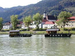
The ferry circuit is route number 2. Starting point is the Engelhartszell municipal office - past the playground - cross the road - left down to Donau-Platz - continue to the ferry - cross the Danube - then left to Haus am Strom - cross the Jochenstein power station - left along the Danube back to Engelhartszell
- Suitable for groups
- Suitable for schools
- Suitable for kids (all ages)
- Suitable for pushchairs
- Suitable for single travelers
- Suitable for friends
- Suitable for couples
- Suitable for children
- Spring
- Summer
- Autumn
- Early winter
Please get in touch for more information.
Marktplatz 61
4090 Engelhartszell
Phone +43 7717 8055 - 16
E-Mail tourismus@engelhartszell.ooe.gv.at
Web www.engelhartszell.at
https://www.engelhartszell.at
Interactive elevation profile
Create PDF
Tour-Details
Path number: 2 - Nordic Walking
Starting place: 4090 Engelhartszell
Destination: 4090 Engelhartszell
duration: 1h 0m
length: 5,9 km
Altitude difference (uphill): 108m
Altitude difference (downhill): 103m
Lowest point: 279m
Highest point: 350m
difficulty: easy
condition: easy
panoramic view: Dreamtour
Paths covering:
Asphalt
powered by TOURDATA | Suggest a change
Suggest changes
Please let us know how we can improve the quality of this object or if there is any incorrect information on this page (eg. opening hours, contact, etc.).
Please fill in all fields marked *.