
Circular route Forsthaus Hinteredt


4391 Waldhausen im Strudengau

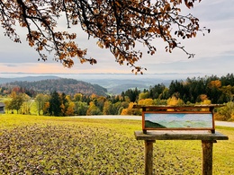
IVV certified circular hiking route to the idyllically situated Forsthaus Hinteredt with numerous viewpoints (view over the Mühlviertel hill country up to the Alpine range)
Recommended season:
- January
- February
- March
- April
- May
- June
- July
- August
- September
- October
- November
- December
- Loop
- Scenic
- Refreshment stops available
- Cultural/historical value
- Geological highlights
- Summit route
Certified, permanent IVV hiking trail
Start at the market square via Klostersteig - Schlossberg - by the Reutner inn along the Ettenberg service road to the Herzog farm, then right at the garage over a meadow path to the Sarmingbach stream. Crossing this and turning right, the ascent leads after 20 m to the left onto a forest path to the farms "Pointner", "Unterlehner" (the last peasant wax farmer in Austria), "Leonhard" to the Forsthaus "Hinteredt". Descent to the "Windschopf" via the forest road to "Schneiderlehner" and "Wolflehner" up to the Hasenebene. From here, we take the forest road heading south to "Hinterberger" continuing to the bathing lake and along the Sarmingbach and the Klostersteig back to the market.
Tip:- Enjoy and pause at the idyllic forest clearing where Forsthaus Hinteredt is located.
- On hot days, don't forget your swimwear for a dive into the bathing lake.
- For culture enthusiasts, a visit to the Waldhausen Abbey Church is recommended (audioguide available via the Danube Stories app).
- Explorations with a pleasurable stop! This route passes directly by the following culinary partner:
Gasthof Schauer
Hiking backpack (including rain cover), sturdy footwear
Bring provisions. You will find refreshment options at the start/finish point, on the Schlossberg, and at the bathing lake.
Paths covering:
further information:
- Flatly
- Board possible


Public Transit
How to reach the Danube Region Upper Austria?
The fastest way to your destination – by train, bus, car, ship, or airplane.
Starting point directly at the Waldhausen bus stop in the Strudengau market
Parking
200 m near Unimarkt
- Spring
- Summer
- Autumn
- Early winter
- Deep winter
Please get in touch for more information.
Markt 14
4391 Waldhausen im Strudengau
Phone +43 7260 4505
E-Mail gemeinde@waldhausen.ooe.gv.at
Web www.tourismus-waldhausen.com
Altitude profile - Circular route Forsthaus Hinteredt
Suggest changes
Please let us know how we can improve the quality of this object or if there is any incorrect information on this page (eg. opening hours, contact, etc.).
Please fill in all fields marked *.