
Donausteig Stage 4_G08 Waldhausen - Grein: "Summit rush - Through the Mühlviertel hilly landscape"


4040 Linz

Donausteig - simply amazing! On this panoramic stage, we hike through the atmospheric hilly landscape of the Aist-Naarn-Kuppenland: from Waldhausen to Bad Kreuzen and down along the Danube to Grein. Along the way, we discover the magnificent Waldhausen Abbey as an end and beginning, divine stonemasonry and their signs, the second-largest castle complex in Upper Austria, the healing waters of the Wolfsschlucht, …
Recommended season:
- March
- April
- May
- June
- July
- August
- September
- October
- Multi-stage route
- Scenic
- Refreshment stops available
- Cultural/historical value
- Geological highlights
- Insider tip
- Summit route
Seal of approval:
- Quality route according to "Österreichisches Wandergütesiegel"
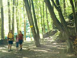
The starting point of this wonderful stage is Waldhausen. The historic market lies in a valley basin surrounded by wooded mountain peaks of the atmospheric Aist-Naarn-Kuppenland. The market and the abbey of the same name are a symbol of the land reclamation of this remote region. Wonderful facades, skillful granite work, beautiful gardens, … make the village a little gem! From the market square, we pass the unique parish church and follow the Klostersteig to the former Waldhausen Abbey - a jewel! The magnificent abbey church tells of god-fearing foundation and fateful splendor. Shortly thereafter, we leave the village area of Waldhausen and hike with gentle ups and downs through the beautiful hilly landscape. At Langenbach, the forested ascent to the edge of the Waldhausen basin begins. Only at the top does the view back reveal the full dimension of the basin - a painstakingly created landscape full of harmony! On the other side of the ridge, the landscape opens up to a viewing balcony: wide views towards the Danube valley, from Ötscher to Traunstein, ... Over forest paths, farm roads, and field paths, we hike down a scenic ridge to the Aumühle in the Gießenbach valley. There begins the summit rush. We briefly follow the meanders of the Gießenbach and then quickly gain height over forest and meadow paths. The views sweep far over the Aist-Naarn-Kuppenland to the Alps. A few meters later, we discover the mystical Moonstone. The descent to Bad Kreuzen proceeds enjoyably through the hilly cultural landscape. Shortly before Bad Kreuzen, we traverse the wild romantic Kasmüllerbach valley. Here the Dr. Otto Fleischanderl trail reminds us of the beginnings of the spa business in Bad Kreuzen. A short ascent to the next ridge brings us to a Donausteig junction. Uphill to the right, we reach the beautiful village center of the historic spa town Bad Kreuzen. Downhill to the left, we reach Kreuzen Castle, once the second-largest fortress complex in Upper Austria. The magnificent panoramic view from the castle's keep is one of the most beautiful on the Donausteig - simply amazing! Over wonderful hiking trails, we descend the wild romantic Wolfsschlucht. Wonderful mixed forest, wildly blocked stream terrain, beautiful light moods, historical spa stations,... shape this special experience. At the end of the Wolfsschlucht, a short farm road leads up to Lehen. From there, we again go down through rural hilly landscape to the Danube in Grein, the gateway to Strudengau. Pure landscape enjoyment - simply amazing!
Discover the following special features with the Donausteig diary:
- Waldhausen - a little gem
- Donausteig starting point "Waldhausen"
- Parish church Waldhausen - divine granite art
- Anniversary bust - Long live the Emperor!
- St. Nepomuk with chronogram
- Waldhausen Abbey - end and beginning
- The Dimbach and the Struden
- Kleingruber farm - a departure house
- ...
Download: Donausteig Diary Stage 4_G08 Waldhausen-Grein
Directions:
From the Donausteig starting point in Waldhausen we first go along the south side of the market square, then past the parish church and the cemetery. Afterwards, the Klostersteig, a magnificent linden avenue, leads us almost level to the former monastery complex of Waldhausen on the Schloßberg. At the intersection with the starting point of the honey extractor trail turn left. After about 200 m, before a beautiful stone wayside shrine, turn right and follow the field path through a short wooded area. At the paved farm road turn left to the next T-junction. Now turn right and go uphill over the road embankment, past the Marian chapel to the small saddle. There, follow the field path to the left over the hill. At Gumpetshof we take the forest path downhill to the right until we reach the paved road near the transformer in Langenbach. Here turn right uphill and after about 400 m turn left. A forest path quickly takes us uphill, past the Kleingruber and Großgruber farms. At the forest road high on the mountain, continue left to the paved road. Then turn right uphill. At the next farms we turn left and after a few meters downhill reach the Donausteig rest area "Dörl, Gameritt". We continue hiking downhill towards the south. Over field paths and short paved sections, we reach the hamlet of Dorferhäuser. From there, a field path takes us in a large right loop further down into the Gießenbach valley to the inn Aumühle. We follow the paved road uphill to the right and after about 250 m turn left onto the paved farm road "Gießenbachtal." On a long uphill stretch, the Donausteig briefly leaves the farm road and immediately follows the Gießenbach to the Klausmühle. There it returns to the farm road. Before a sharp right curve, a forest path branches off to the left. Over this, we soon reach a large four-sided farm. Here turn right, past the second residential house. Then a sharp left-right curve combination takes us through a short wooded area and over the fields to the next farmstead. Over a paved farm road, we go downhill to reach the Donausteig rest area "Mondstein". We follow the paved road downhill on the right and cross the next intersection straight ahead—a driveway takes us through the following wooded area. Then we briefly follow the paved road to the left and just before the large quadrangular farm turn right again onto a field path. First over meadows, then downhill through the forest, we reach a paved road by a stream. Here turn right uphill to the Kollroß Chapel. Cross its intersection straight ahead. The path now goes through the valley hollow, past a farm, and in an S-curve to the paved road on the opposite hillside. There turn left downhill. In the forest, a hiking trail branches off to the right and leads past the forest shrine through the Kasmüllerbach valley. At a former mill, we reach the paved road again, which then shortly curves sharply right uphill to the Bad Kreuzen junction point (large intersection, granite wayside shrine). Those who want to enter the market town of Bad Kreuzen must turn right here and follow the opposite road uphill into the village. The path to Grein goes left here. Immediately past Castle Kreuzen and the Donausteig rest area "Burg Kreuzen", a hiking trail then leads downhill through the Wolfsschlucht. At the southern end of the gorge, follow the forest road uphill to the left to reach a farmstead, then turn right downhill. In front of the Speckalm (Lehen) the path turns left and follows the farm road downhill. From a white wooden chapel, a meadow path brings us to the next farmstead and from there a hiking trail through the forest to a paved road. We follow this to the left to the right-angled junction. There turn right downhill, past the Hahnwirt. At the next forest edge, turn sharply right. Through a wooded area and over meadows, we reach the Donausteig rest area "Mühberg". Meadow and forest paths now lead down to the first residential street of Grein. At the T-junction turn left and always follow the larger road to the railway tracks. In the green area afterwards is the Donausteig rest area "Storchenblick" (opposite Luger nursery). The Donausteig skirts this green area on the south side and leads over a footpath to the town center of Grein. The Donausteig starting point "Grein" is located directly on the Danube promenade.
To facilitate your orientation, the Donausteig has been equipped with its own orientation system - the description can be found here.
Tip:
Take your time and enjoy!Equipment:
In addition to your personal hiking equipment, there are no special requirements.Additional information:
WGD Donau Upper Austria Tourism GmbH
Lindengasse 9
4040 Linz, Austria
Tel. +43(0)732/7277-800
Fax. +43(0)732/7277-804
info@donausteig.com
Waldhausen
4391 Waldhausen, Markt 14
Tel.: +43(0)7260/4505
tourismus@waldhausen.ooe.gv.at
www.waldhausen.at
Grein/Danube
4360 Grein, Stadtplatz 7
Tel./Fax: +43(0)7268/7055
info.grein@oberoesterreich.at
www.oberoesterreich.at/grein
Paths covering:
further information:
- Multi-day tour
- Board possible
")
")
")


")


Direction information: Departure
Direction information: Destination
")
")
.jpg")
")
")
")
Getting there
The Donausteig starting point "Waldhausen" is located within sight of the southern exit of the market square in Waldhausen (GPS: A-4391 Waldhausen, Markt).
Public Transit
Waldhausen can be reached by bus. A return transfer from Grein to Waldhausen is possible by bus. Information about the times can be found at http://www.ooevv.at .
Parking
The few parking spaces in the market square are intended for short shopping stays. Unlimited free parking is possible at the cemetery car park about a 3-minute walk from the market square.
free entrance
- Suitable for groups
- Suitable for kids (all ages)
- Pets allowed
- Spring
- Summer
- Autumn
Please get in touch for more information.
Lindengasse 9
4040 Linz
Phone +43 732 7277 - 800
Fax machine +43 732 7277 - 804
E-Mail tourismus@waldhausen.ooe.gv.at
Web www.donauregion.at
Web www.waldhausen.at/system/web/defaul…
https://www.waldhausen.at/system/web/default.aspx?sprache=1

Altitude profile - Donausteig Stage 4_G08 Waldhausen - Grein: "Summit rush - Through the Mühlviertel hilly landscape"
Suggest changes
Please let us know how we can improve the quality of this object or if there is any incorrect information on this page (eg. opening hours, contact, etc.).
Please fill in all fields marked *.