


Pfenningberg: From the water to the summit


- Suitable for families
Interactive elevation profile
Create PDF
Tour-Details
Starting place: 4040 Steyregg
Destination: 4221 Steyregg
duration: 2h 49m
length: 9,0 km
Altitude difference (uphill): 364m
Altitude difference (downhill): 366m
Lowest point: 251m
Highest point: 615m
difficulty: medium
condition: medium
panoramic view: Great panorama
Paths covering:
Asphalt, Path / trail, Street
powered by TOURDATA | Suggest a change
Short description:
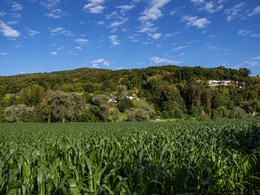
A walk that shows the interplay of nature, culture and industry in the city.
A walk that shows the interplay of nature, culture and industry in the city.
Quality of experience: ****
Recommended season:
- January
- February
- March
- April
- May
- June
- July
- August
- September
- October
- November
- December
Properties:
- Scenic
- Refreshment stops available
- Family friendly
Heading out of town on the Pleschinger Landesstraße, the climb up the Pfenningberg begins after a few metres on the left. Along the steep road you have a view of the town. If you follow the forest path, you will reach the summit at the fork in the road on the left. Even without a view, the summit cross is worth the short climb. The path continues to Steyregg.
Equipment:
Hiking backpack (incl. rain cover), sturdy shoes
Additional information:
Interesting points along the hiking trail announce:
Pfenningberg summit, Steyregg
Starting point: Pleschinger Landstrasse / Steyregg town square
Destination: Pleschinger Landstrasse / Steyregg town square
further information:
- Board possible
Accessibility / arrival
Parking
Parking Pleschingersee car park (public, free of charge)
Public Transit
Location and getting there
How to arrive in the Danube Upper Austrian region?
The fast way to your destination – by train, bus, car, boat or plane.
Linz AG line 33 bus stop (Plesching stop)
Parking
Parking Pleschingersee car park (public, free of charge)
Most economical season
- Spring
- Summer
- Autumn
- Early winter
- Deep winter
Please get in touch for more information.
Weissenwolffstraße 3
4221 Steyregg
Phone +43 732 640155
E-Mail office@steyregg.at
Web www.steyregg.at
https://www.steyregg.at
Interactive elevation profile
Create PDF
Tour-Details
Starting place: 4040 Steyregg
Destination: 4221 Steyregg
duration: 2h 49m
length: 9,0 km
Altitude difference (uphill): 364m
Altitude difference (downhill): 366m
Lowest point: 251m
Highest point: 615m
difficulty: medium
condition: medium
panoramic view: Great panorama
Paths covering:
Asphalt, Path / trail, Street
powered by TOURDATA | Suggest a change
Suggest changes
Please let us know how we can improve the quality of this object or if there is any incorrect information on this page (eg. opening hours, contact, etc.).
Please fill in all fields marked *.