


Wanderrunde Neuaigen


- Flatly
Interactive elevation profile
Create PDF
Tour-Details
Starting place: 4362 Bad Kreuzen
Destination: 4362 Bad Kreuzen
duration: 0h 45m
length: 2,6 km
Altitude difference (uphill): 63m
Altitude difference (downhill): 58m
Lowest point: 421m
Highest point: 479m
difficulty: easy
condition: easy
panoramic view: Individual Views
Paths covering:
Asphalt
powered by TOURDATA | Suggest a change
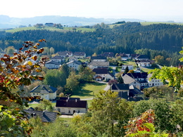
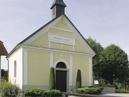
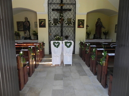
5e Neuaigen (circular route 3,450m)
Neuaigen is known for the pilgrimage church "Zum Aigner Kreuz" The Villa-Böck-Weg and Aignerbergweg paths lead from the village down to Neuaigen. Neuaigen is known for its pilgrimage chapel "Zum Aigner Kreuz". In the chapel you will find interesting votive pictures, which were donated out of gratitude by those who were healed or saved. Even today, groups of pilgrims still come to this Christian gem. The "Zum Aigner Kreuz" inn invites you to take a break before you walk back to the village via the Kühweidsiedlung (beautiful view of the castle and the village) and the Postgassl.
Neuaigen is known for the pilgrimage church "Zum Aigner Kreuz" The Villa-Böck-Weg and Aignerbergweg paths lead from the village down to Neuaigen. Neuaigen is known for its pilgrimage chapel "Zum Aigner Kreuz". In the chapel you will find interesting votive pictures, which were donated out of gratitude by those who were healed or saved. Even today, groups of pilgrims still come to this Christian gem. The "Zum Aigner Kreuz" inn invites you to take a break before you walk back to the village via the Kühweidsiedlung (beautiful view of the castle and the village) and the Postgassl.
Most economical season
- Spring
- Summer
- Autumn
Please get in touch for more information.
Nr. 20a
4362 Bad Kreuzen
mobile +43 681 20583484
E-Mail info@gsundleben.at
Web www.gsundleben.at
Web www.bad-kreuzen.at
http://www.gsundleben.at
http://www.bad-kreuzen.at
http://www.bad-kreuzen.at
Interactive elevation profile
Create PDF
Tour-Details
Starting place: 4362 Bad Kreuzen
Destination: 4362 Bad Kreuzen
duration: 0h 45m
length: 2,6 km
Altitude difference (uphill): 63m
Altitude difference (downhill): 58m
Lowest point: 421m
Highest point: 479m
difficulty: easy
condition: easy
panoramic view: Individual Views
Paths covering:
Asphalt
powered by TOURDATA | Suggest a change
Suggest changes
Please let us know how we can improve the quality of this object or if there is any incorrect information on this page (eg. opening hours, contact, etc.).
Please fill in all fields marked *.