


Schlossblickrunde


- All weather
- culinary interesting
- culturally interesting
- Flatly
- Possible accommodation
Interactive elevation profile
Create PDF
Tour-Details
Starting place: 4113 St. Martin im Mühlkreis
Destination: 4113 St. Martin im Mühlkreis
duration: 4h 0m
length: 14,3 km
Altitude difference (uphill): 422m
Altitude difference (downhill): 422m
Lowest point: 296m
Highest point: 549m
difficulty: difficult
condition: difficult
panoramic view: Dreamtour
Paths covering:
Asphalt, Gravel, Hiking trail
powered by TOURDATA | Suggest a change
roadblock: Lock Schlossblickrunde
Description: The Schlossblickrunde is closed until further notice due to severe storm damage.
Demanding circular hiking trail with "ups and downs" in extremely varied landscapes; medium-difficulty day tour
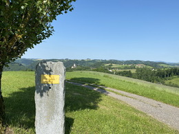
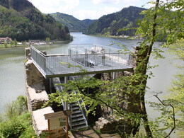
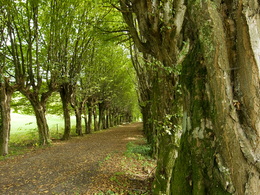
The circular route starts at the market square in St. Martin i. M. You follow the "Schlossblickrunde" signposts to the Großpremser riding estate. There you have marvellous views of the Bohemian Forest and the Alps. After the Premser pond, the trail briefly follows farm tracks before branching off to the left into the forest. Hikers reach the Danube through the wild and romantic Draßenbach valley. Here the path leads upstream along the Danube cycle path. Finally, you reach the Donaublick Kettenturm and the Danube village of Untermühl via the well-secured rocky path. After a refreshment stop at the inn, the path leads uphill past the stone wall, over the steps and past the 500-year-old oak tree to Neuhaus Castle. After the Meierhof, turn right downhill to Falkenbach, then right over the bridge and uphill to Bockhübel with its panoramic views. Continue through the hilly landscape of the Mühlviertel on the goods road to Grub and in the forest to the Auhäusern. From there, turn right again on forest and meadow paths to the Adsdorf farm and continue to the starting point.
The circular route starts at the market square in St. Martin i. M. You follow the "Schlossblickrunde" signposts to the Großpremser riding estate. There you have marvellous views of the Bohemian Forest and the Alps. After the Premser pond, the trail briefly follows farm tracks before branching off to the left into the forest. Hikers reach the Danube through the wild and romantic Draßenbach valley. Here the path leads upstream along the Danube cycle path. Finally, you reach the Donaublick Kettenturm and the Danube village of Untermühl via the well-secured rocky path. After a refreshment stop at the inn, the path leads uphill past the stone wall, over the steps and past the 500-year-old oak tree to Neuhaus Castle. After the Meierhof, turn right downhill to Falkenbach, then right over the bridge and uphill to Bockhübel with its panoramic views. Continue through the hilly landscape of the Mühlviertel on the goods road to Grub and in the forest to the Auhäusern. From there, turn right again on forest and meadow paths to the Adsdorf farm and continue to the starting point.
- All weather
- Suitable for groups
- Suitable for seniors
- Suitable for single travelers
- Suitable for friends
- Suitable for couples
- Spring
- Summer
- Autumn
Please get in touch for more information.
4113 St. Martin im Mühlkreis
Phone +43 7232 2105
E-Mail gemeindeamt@sankt-martin.at
Web www.tourismus.sankt-martin.at/somme…
http://www.tourismus.sankt-martin.at/sommer-wandern.php
Interactive elevation profile
Create PDF
Tour-Details
Starting place: 4113 St. Martin im Mühlkreis
Destination: 4113 St. Martin im Mühlkreis
duration: 4h 0m
length: 14,3 km
Altitude difference (uphill): 422m
Altitude difference (downhill): 422m
Lowest point: 296m
Highest point: 549m
difficulty: difficult
condition: difficult
panoramic view: Dreamtour
Paths covering:
Asphalt, Gravel, Hiking trail
powered by TOURDATA | Suggest a change
Suggest changes
Please let us know how we can improve the quality of this object or if there is any incorrect information on this page (eg. opening hours, contact, etc.).
Please fill in all fields marked *.