


Genuss-Wanderung


- culinary interesting
- Flatly
Interactive elevation profile
Create PDF
Tour-Details
Path number: 4 - Wanderweg
Starting place: 4725 St. Aegidi
Destination: 4725 St. Aegidi
duration: 3h 13m
length: 11,7 km
Altitude difference (uphill): 196m
Altitude difference (downhill): 196m
Lowest point: 523m
Highest point: 613m
difficulty: easy
condition: medium
panoramic view: Individual Views
Paths covering:
Asphalt, Gravel
powered by TOURDATA | Suggest a change
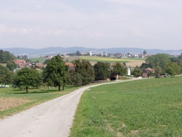
This hiking trail has trail number 4. The physical well-being is the top priority here. We start at the former Kellerwirt inn opposite the warehouse. We walk a short distance along the footpath towards Schärding and pass the Christinenhof(+43 7717 7851), a meeting point for riders. We then turn right onto the Reiting goods road and after approx. 200 metres turn left in a south-easterly direction along a forest path to the road. In Kößlau we briefly walk on tarmac again, change to a meadow path, cross the road twice in succession and reach a field path. Initially along the edge of the forest, we then walk through a forest and come to Walleiten on a meadow and field path to Gasthaus Sageder (Tel. 7393).
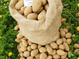
After a stop for refreshments, we take the Sagedt goods road. Passing meadows and potato fields, we turn left onto the long-distance hiking trail in Sagedt, cross the Keßlastraße in Edern and head for the Auinger inn in Fraunhof (Tel. 7337) on meadow and farm tracks.
From Fraunhof, the road leads us slightly uphill for approx. 400 metres and before a section of forest on the left-hand side into a forest and meadow path. In Grübl we walk past the Sauwald potato hall. In Lehen, we return to paved farm tracks, keep right at the fork in the path, turn left at the blocks of flats and arrive in the village of St. Aegidi. To round off our enjoyable hike, the Kirchenwirt (tel. 7304) welcomes us next to the parish church.
International dialling code: +43(0)7717 71000
Most economical season
- Spring
- Summer
- Autumn
Please get in touch for more information.
St. Aegidi 10
4725 St. Aegidi
Phone +43 7717 7355 - 0
Fax machine +43 7717 7355 - 4
E-Mail gemeinde@st-aegidi.ooe.gv.at
Web www.st-aegidi.at
https://www.st-aegidi.at
Interactive elevation profile
Create PDF
Tour-Details
Path number: 4 - Wanderweg
Starting place: 4725 St. Aegidi
Destination: 4725 St. Aegidi
duration: 3h 13m
length: 11,7 km
Altitude difference (uphill): 196m
Altitude difference (downhill): 196m
Lowest point: 523m
Highest point: 613m
difficulty: easy
condition: medium
panoramic view: Individual Views
Paths covering:
Asphalt, Gravel
powered by TOURDATA | Suggest a change
Suggest changes
Please let us know how we can improve the quality of this object or if there is any incorrect information on this page (eg. opening hours, contact, etc.).
Please fill in all fields marked *.