


Dem Pesenbach entlang


- Suitable for kids (all ages)
- Flatly
Interactive elevation profile
Create PDF
Tour-Details
Starting place: 4101 Feldkirchen an der Donau
Destination: 4101 Feldkirchen an der Donau
duration: 1h 41m
length: 4,4 km
Altitude difference (uphill): 299m
Altitude difference (downhill): 131m
Lowest point: 281m
Highest point: 453m
difficulty: medium
condition: medium
panoramic view: Individual Views
Paths covering:
Hiking trail
powered by TOURDATA | Suggest a change
Impressive hike in the nature reserve
ATTENTION: No winter service!
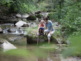
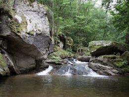
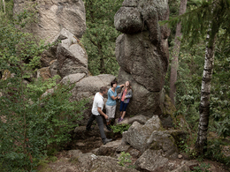
Tired? Exhausted? Tired? There are two ways to combat this: either a revitalising Kneipp cure at the Sisters of Mary in Bad Mühllacken or a hike into the Pesenbach Valley, which flows into the lowlands at the Kurhaus. The route into the romantic, protected forest gorge first leads to the natural swimming pool, the spring intake for the spa and the Klausbrücke bridge. Beyond the bridge, a comfortable promenade path leads further into the valley. However, we stay on the right bank, above which an initially wide path winds up and down. We soon reach the turn-off to the Schlagerwirt, where we can take a second detour, this time for culinary reasons. At the bottom of the valley, however, you come to a small waterfall and the 5-metre-deep Grüner Tümpel (another path on the right leads to the Schlagerwirt - a tip for the way back). We hike further into the narrow valley incision, past the Black Gorge, the Sunntümpel and the Blauer Tümpel. We reach the Blaue Gasse, the legendary Teufelsbottich and finally, after a short but steep climb, the landmark of the Pesenbachklamm gorge: in the middle of the forest, the 12-metre-high Kerzenstein towers into the air - slender, valued by climbers as a training ground and crowned with a cross. Geologists argue about whether it was really formed by frost weathering during the last ice age. For folklorists, on the other hand, it is clear that it is a fertility stone that has been worshipped since time immemorial, i.e. a place of power. Most visitors turn back here to hike back to the starting point along one of the aforementioned trail options.
Rest options:
Gasthaus Schlagerwirt, Jausenstation Fürstberger, Cafe Einkehr (in the Kurhaus Bad Mühllacken), Cafe Rechberger, Hotel Restaurant Faustschlössl.
ATTENTION: No winter service!
Tired? Exhausted? Tired? There are two ways to combat this: either a revitalising Kneipp cure at the Sisters of Mary in Bad Mühllacken or a hike into the Pesenbach Valley, which flows into the lowlands at the Kurhaus. The route into the romantic, protected forest gorge first leads to the natural swimming pool, the spring intake for the spa and the Klausbrücke bridge. Beyond the bridge, a comfortable promenade path leads further into the valley. However, we stay on the right bank, above which an initially wide path winds up and down. We soon reach the turn-off to the Schlagerwirt, where we can take a second detour, this time for culinary reasons. At the bottom of the valley, however, you come to a small waterfall and the 5-metre-deep Grüner Tümpel (another path on the right leads to the Schlagerwirt - a tip for the way back). We hike further into the narrow valley incision, past the Black Gorge, the Sunntümpel and the Blauer Tümpel. We reach the Blaue Gasse, the legendary Teufelsbottich and finally, after a short but steep climb, the landmark of the Pesenbachklamm gorge: in the middle of the forest, the 12-metre-high Kerzenstein towers into the air - slender, valued by climbers as a training ground and crowned with a cross. Geologists argue about whether it was really formed by frost weathering during the last ice age. For folklorists, on the other hand, it is clear that it is a fertility stone that has been worshipped since time immemorial, i.e. a place of power. Most visitors turn back here to hike back to the starting point along one of the aforementioned trail options.
Rest options:
Gasthaus Schlagerwirt, Jausenstation Fürstberger, Cafe Einkehr (in the Kurhaus Bad Mühllacken), Cafe Rechberger, Hotel Restaurant Faustschlössl.
- Free entry
- Suitable for kids (all ages)
- Suitable for single travelers
- Spring
- Summer
- Autumn
- Early winter
Please get in touch for more information.
Hauptstraße 1
4101 Feldkirchen an der Donau
Phone +43 7233 7190
E-Mail info@feldkirchenanderdonau.at
Web www.feldkirchenanderdonau.at
http://www.feldkirchenanderdonau.at
Interactive elevation profile
Create PDF
Tour-Details
Starting place: 4101 Feldkirchen an der Donau
Destination: 4101 Feldkirchen an der Donau
duration: 1h 41m
length: 4,4 km
Altitude difference (uphill): 299m
Altitude difference (downhill): 131m
Lowest point: 281m
Highest point: 453m
difficulty: medium
condition: medium
panoramic view: Individual Views
Paths covering:
Hiking trail
powered by TOURDATA | Suggest a change
Suggest changes
Please let us know how we can improve the quality of this object or if there is any incorrect information on this page (eg. opening hours, contact, etc.).
Please fill in all fields marked *.