


Wadiloipe rot


Interactive elevation profile
Create PDF
Tour-Details
Starting place: 4391 Waldhausen im Strudengau
Destination: 4391 Waldhausen im Strudengau
duration: 1h 37m
length: 5,7 km
Altitude difference (uphill): 117m
Altitude difference (downhill): 114m
Lowest point: 423m
Highest point: 478m
difficulty: medium
condition: medium
panoramic view: Individual Views
Paths covering:
snow
powered by TOURDATA | Suggest a change
Trail not in operation
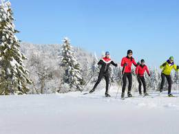
Cross country skiing in Waldhausen im StrudengauLenght: 6,2 km The idyllic village of Waldhausen, Strudengau lies at an elevation of 470 meters at the southeast edge of the Mühlviertel. Discover the beautiful, romantic cross-country routes through the rolling hills of the lower Mühlviertel.
The trail network of Waldhausen is characterized by numerous wooded hilltops from which you have beautiful views of the near Danube Valley. The trails that are groomed classic, run past beautiful streams and snow-covered forests. Immerse yourself in the magical world of winter Waldhausen, Strudengau.
The entrance of the trails located at the Gasthof Rose Mayer - in the cozy dining room of the inn you can strengthen yourself and warm up before or after your cross country round.
Information about the current track situation you get at Gasthof Rose Mayer: +43 (0) 7260/4382
free entrance
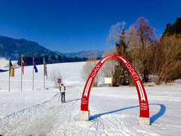
WADI Loipe - rot - Start
WADI Loipe - rot - Ziel
General price information
voluntary donations
Most economical season
- Deep winter
Please get in touch for more information.
Markt 14
4391 Waldhausen im Strudengau
Phone +43 7260 4505 - 11
Fax machine +43 7260 4508 - 8
E-Mail tourismus@waldhausen.ooe.gv.at
Web www.oberoesterreich.at/waldhausen
Web tourismus-waldhausen.com
http://www.oberoesterreich.at/waldhausen
http://tourismus-waldhausen.com
http://tourismus-waldhausen.com
Interactive elevation profile
Create PDF
Tour-Details
Starting place: 4391 Waldhausen im Strudengau
Destination: 4391 Waldhausen im Strudengau
duration: 1h 37m
length: 5,7 km
Altitude difference (uphill): 117m
Altitude difference (downhill): 114m
Lowest point: 423m
Highest point: 478m
difficulty: medium
condition: medium
panoramic view: Individual Views
Paths covering:
snow
powered by TOURDATA | Suggest a change
Suggest changes
Please let us know how we can improve the quality of this object or if there is any incorrect information on this page (eg. opening hours, contact, etc.).
Please fill in all fields marked *.