


Waldkirchen: 4/4-Blick Loop Trail


- Flatly
Interactive elevation profile
Create PDF
Tour-Details
Paths covering:
Kleines Kösslbachtal Valley- 4/4- Blick vantage point - Waldkirchen – Bräukapelle Chapel - Wesenufer
Technique: *
Quality of experience: ******
Recommended season:
- April
- May
- June
- July
- August
- September
- October
- November
Properties:
- Loop
- Scenic
- Refreshment stops available
- Botanical highlights
- Faunistic highlights
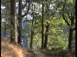
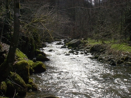
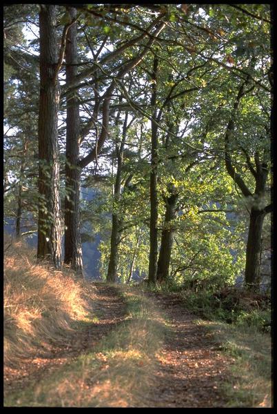
Starting point is the boat landing stage in Wesenufer. The trail follows the road north-westwards towards “Kagerer Jagastein” until the underpass of the federal road. Having passed it the trail continues to the left. After the last farm house the asphalt trail merges into a country lane, some sections of which lead through the forest, that eventually leads into Kleine Kößlbachtal Valley. The valley has been put under a protection order in 1996 and has a special importance in the natural area between Passau and Schlögen. The brook has created a V-shaped erosion valley that features steep slopes, rocky ridges and natural forests. On the trails of the area one can experience this special area. In the valley the trail continues as forestry trail and leads uphill. Again and again one can enjoy nice views of the valley. After a left-hand bend the trail branches off to the right and climbs steeply uphill. From now on the area is completely unspoilt. After some time one gets to a section with stone runs. They have emerged from underground weathering of primary rocks and have resurfaced. After this impressive section the trail leads out of the forest and on a country lane one gets to a farm. Now one follows the road towards Atzersdorf and passes 4/4-Blick vantage point that invites to enjoy a break. From the vantage point (535m of altitude) one can see the four sections of the province of Upper Austria. The view covers the green hills and colourful meadows down in the Danube Valley. In Atzersdorf you can enjoy a break stop. From Atzersdorf the trail follows the road to Aichberg. There you keep to the left and on a country lane you get down to the forest. The section through the forest to Waldkirchen is relatively level. Having arrived there it branches off sharply to the left before one gets into the village centre. There you follow the continiously sloping Wesener district road down to the forest. You pass Bräukapelle Chapel, a popular pilgrimage place. The chapel's spring is said to have healing properties. Then you get back to the road and eventually Wesenufer.
Directions:
Der Weg führt nordwestlich in Richtung "Kagerer Jagasteig" bis zur Unterführung unter der Bundesstraße. Nach dieser zweigt er links auf eine Bauernstraße ab. Nach dem letzten Bauernhausweiter auf einem Feldweg, der zum Teil auch durch den Wald führt und schließlich im kleinen Kößlbachtal (seit 1996 Naturschutzgebiet) mündet. Im V-förmigen Erosionstal führt der Weg dann einen Forstweg entlang stetig nach oben. Nach einer Linkskehre zweigt der Weg vom Forstweg rechts steil in den Wald ab. Nach einiger Zeit erreicht man dann einen Abschnitt mit Blockhalden. Nach diesem eindrucksvollen Abschnitt führt der Weg aus dem Wald heraus über einen Wiesenweg und erreicht einen Bauernhof. Man folgt der Straße Richtung Atzersdorf und kommt dabei am Vierviertelblick vorbei, der zur Rast einlädt. Von Atzersdorf führt der Weg auf der Straße bis nach Aichberg, wo man sich links hält und über einen Wiesenweg hinunter zum Wald geht. Durch den Wald führt der Weg dann relativ eben bis Waldkirchen. Dort angekommen zweigt er scharf links ab, noch bevor man ins Ortszentrum kommt. Von dort folgt man dem Weg durch den Wald auf der alten Wesener Bezirksstraße. Dort kommt man an der „Bräukapelle“ vorbei. Man erreicht wieder die Straße und schließlich Wesenufer.
Tip:
Kleines Kößlbachtal Nature Reserve
Equipment:
Wanderrucksack (inkl. Regenhülle), festes Schuhwerk
Additional information:
Waldkirchen am Wes en Municipal Office
4085 Waldkirchen am Wesen
Tel.: 0043(0)7718 7255 Fax. 14
www.waldkirchen.at
further information:
- Flatly
- Board possible
")
")


")

")

")


")

")
")
")
")
Public Transit
Bus (www.postbus.at),
Schiffsanlegestelle direkt in Wesenufer
Parking
Public car parks of the market municipality of Wesenufer
- Spring
- Summer
- Autumn
- Early winter
Please get in touch for more information.
Waldkirchen 61
4085 Waldkirchen am Wesen
Phone +43 7718 7255
mobile +43 664 3601370
E-Mail gahleitner@waldkirchen.ooe.gv.at
Web www.donauregion.at/waldkirchen
Web www.donauregion.at
http://www.donauregion.at
Interactive elevation profile
Create PDF
Tour-Details
Paths covering:
Suggest changes
Please let us know how we can improve the quality of this object or if there is any incorrect information on this page (eg. opening hours, contact, etc.).
Please fill in all fields marked *.