


Grenzlandloipe


- All weather
- Suitable for families
- Suitable for kids (all ages)
- culturally interesting
- Flatly
- Possible accommodation
Interactive elevation profile
Create PDF
Tour-Details
Starting place: 4143 Neustift im Mühlkreis
Destination: 4143 Neustift im Mühlkreis
duration: 1h 26m
length: 5,4 km
Altitude difference (uphill): 70m
Altitude difference (downhill): 71m
Lowest point: 581m
Highest point: 645m
difficulty: easy
condition: medium
panoramic view: Great panorama
Paths covering:
snow
powered by TOURDATA | Suggest a change
Trail not in operation
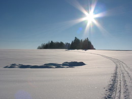
Grenzlandloipe Cross-border trail connecting Austria and Bavaria.Entrances:
Gottsdorf (D)
Neustift (A) - leisure centre
Pühret (A) - village square
Parking
- Parking space: 20
- Bus parking space: 5
- All weather
- Suitable for groups
- Suitable for schools
- Suitable for kids (all ages)
- Deep winter
Please get in touch for more information.
4143 Neustift im Mühlkreis
Phone +43 7284 8155
mobile +43 664 1119382
E-Mail info@familienurlaub-neustift.at
Web www.familienurlaub-neustift.at
https://www.familienurlaub-neustift.at
You can also visit us on
Visit us on FacebookInteractive elevation profile
Create PDF
Tour-Details
Starting place: 4143 Neustift im Mühlkreis
Destination: 4143 Neustift im Mühlkreis
duration: 1h 26m
length: 5,4 km
Altitude difference (uphill): 70m
Altitude difference (downhill): 71m
Lowest point: 581m
Highest point: 645m
difficulty: easy
condition: medium
panoramic view: Great panorama
Paths covering:
snow
powered by TOURDATA | Suggest a change
Suggest changes
Please let us know how we can improve the quality of this object or if there is any incorrect information on this page (eg. opening hours, contact, etc.).
Please fill in all fields marked *.